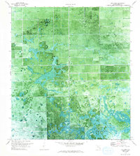
1970 Map of Hog Cypress
USGS Topo · Published 1993About this map
Hog Cypress dominates the southern reaches of this Hendry County landscape, shown here as it transitioned through the early 1970s. The area is defined by a rigorous grid of drainage and irrigation, evidenced by the L-1 Canal and numerous Pump and Windmill sites that supported agricultural development in the Florida Everglades. Central to the northern section is the Airglades Airport, its runways etched into a landscape of geometric fields and natural wetlands. This orthophotomap provides a rare hybrid view of the era, combining traditional topographic surveying with an aerial photogrammetric base. The presence of Flaghole Road and various section lines highlights the systematic division of what was once a seasonal swamp, capturing the tension between South Florida’s natural hydrology and the persistent reach of mid-century civil engineering.
Find a feature on this map
9 named features on this map. Tap any name to fly to it.
Don’t see what you’re looking for? This feature index may not catch every label — zoom into the map to look around manually.
Map Details
Editions of this 1970 Hog Cypress Map
2 editions found
Other maps of this area

1956 · West Palm Beach
USGS Topo · 1:250,000

1957 · West Palm Beach
USGS Topo · 1:250,000

1958 · West Palm Beach
USGS Topo · 1:250,000

1970 · Moore Haven
USGS Topo · 1:24,000

1970 · Lake Harbor SW
USGS Topo · 1:24,000

1970 · Clewiston South
USGS Topo · 1:24,000

1970 · La Belle 4 SE
USGS Topo · 1:24,000

1970 · La Belle 4 NW
USGS Topo · 1:24,000

1970 · La Belle 4 NE
USGS Topo · 1:24,000

1971 · La Belle 4 SW
USGS Topo · 1:24,000