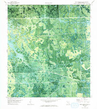
1970 Map of Devils Garden Slough
USGS Topo · Published 1993About this map
Devils Garden Slough defines this region of the Florida Everglades, captured here in a 1970 orthophotomap that reveals the complex drainage and vegetation patterns of the interior wetlands. The orthophoto format, produced from aerial photography by the U.S. Geological Survey and USC&GS, provides a rare visual of how the land was being managed and divided just before the mid-century's intensive agricultural expansion. Movement through this water-rich landscape was largely restricted to the straight-line corridors of Hill Grade Road and Dooley Road, which cut across the natural flow of the slough. These roads served as the primary infrastructure for the developing citrus groves and cattle pastures visible in the rectangular clearings that contrast sharply with the native cypress and marshland. The map also includes dotted land lines established by private surveys, showing the early efforts to organize and parcel this once-remote section of Hendry County.
Find a feature on this map
5 named features on this map. Tap any name to fly to it.
Don’t see what you’re looking for? This feature index may not catch every label — zoom into the map to look around manually.
Map Details
Editions of this 1970 Devils Garden Slough Map
2 editions found
Other maps of this area

1956 · West Palm Beach
USGS Topo · 1:250,000

1957 · West Palm Beach
USGS Topo · 1:250,000

1958 · West Palm Beach
USGS Topo · 1:250,000

1970 · Lake Harbor SW
USGS Topo · 1:24,000

1970 · Clewiston South
USGS Topo · 1:24,000

1970 · La Belle 4 SE
USGS Topo · 1:24,000

1970 · La Belle 4 NW
USGS Topo · 1:24,000

1970 · La Belle 4 NE
USGS Topo · 1:24,000

1971 · La Belle 4 SW
USGS Topo · 1:24,000

1974 · Immokalee 1 NE
USGS Topo · 1:24,000