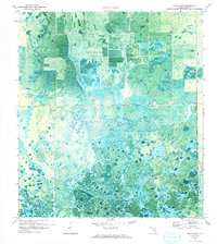
1970 Map of Grassy Marsh
USGS Topo · Published 1993About this map
Grassy Marsh dominates this 1970 orthophotomosaic, revealing a landscape defined by the transition from natural wetland to managed agricultural land. In the northern sections, systematic grid patterns and infrastructure like a Radio Tower and multiple Pump stations signal the encroachment of drainage and cultivation into the interior. These features reflect the mid-century effort to reclaim Florida's interior wetlands for productivity, with dikes and canals cutting through the native vegetation. Further south, the terrain reverts to the intricate, organic patterns of Collins Slough, where water-carved channels and scattered cypress heads create a complex mosaic of sawgrass and sloughs. This aerial perspective documents the precise boundary where mechanical land management meets the native hydrological systems of Hendry County during a period of rapid environmental modification.
Find a feature on this map
5 named features on this map. Tap any name to fly to it.
Don’t see what you’re looking for? This feature index may not catch every label — zoom into the map to look around manually.
Map Details
Editions of this 1970 Grassy Marsh Map
2 editions found
Other maps of this area

1956 · West Palm Beach
USGS Topo · 1:250,000

1957 · West Palm Beach
USGS Topo · 1:250,000

1958 · West Palm Beach
USGS Topo · 1:250,000

1958 · Felda SE
USGS Topo · 1:24,000

1958 · Goodno
USGS Topo · 1:24,000

1958 · Felda NE
USGS Topo · 1:24,000

1970 · Moore Haven
USGS Topo · 1:24,000

1970 · La Belle 4 SE
USGS Topo · 1:24,000

1970 · La Belle 4 NW
USGS Topo · 1:24,000

1970 · La Belle 4 NE
USGS Topo · 1:24,000