1900s (20th Century) Maps of Hendry County, Florida
Explore 39 historic maps of Hendry County from the 1900s (20th Century). These maps offer a rare glimpse into what life looked like during the 1900s — showing old roads, neighborhoods, homes, and landmarks that have changed or disappeared over time.
Whether you're researching your family's past, planning a metal detecting trip, or studying how Hendry County's landscape evolved across the 1900s, these high-resolution maps are a powerful tool for exploring the history of this region.
- Focus on a specific era: All maps on this page are from the 1900s, giving you a focused view of this time period.
- See what’s changed: Compare century-old streets, trails, and buildings to today's modern landscape using overlays and satellite layers.
- Research with precision: Use these maps for genealogy, historical research, land use analysis, or educational projects.
- View, download, or print: Maps are fully viewable online in high resolution, and can be downloaded or printed for your own records.
Start exploring Hendry County's history through authentic maps from the 1900s. This is your window into the past.
Hendry County, FL maps
(39)- 1956 Map of West Palm Beach, 1964 Print
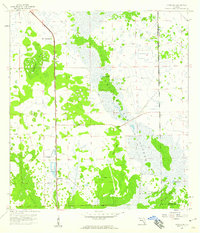
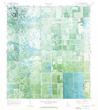
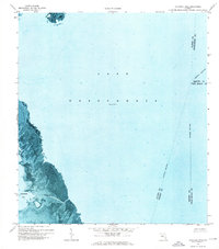
 1956 West Palm Beach1964 Print · USGSSouth Florida during the mid-fifties exhibits a fascinating balance between expanding coastal cities and the vast interior wetlands. Researchers can trace the development of inland settlements like Immokalee and Okeelanta or locate vanished landmarks like Chosen and Buckingham Cem.2 unique versions available
 - 1957 Map of West Palm Beach
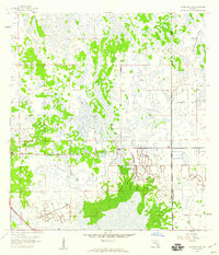
 1957 West Palm Beach1957 Print · USGSSouthern Florida in the mid-fifties reveals a landscape defined by massive drainage canals and the early expansion of the Gold Coast. Genealogists and historians can trace industrial outposts like the Sugar plant and Everglades Labor Center, or locate the Jupiter Auxiliary Air Force Base.
 - 1957 Map of Telegraph Swamp SE, 1959 Print
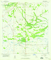
 1957 Telegraph Swamp SE1959 Print · USGSThe Florida interior during the mid-1950s reveals a landscape where the corners of four counties meet among sprawling wetlands. Researchers can locate the Fort Denaud Cem and trace seasonal watercourses like Jacks Branch and Cypress Cr.3 unique versions available
 - 1958 Map of West Palm Beach
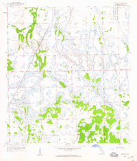
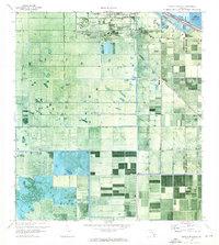
 1958 West Palm Beach1958 Print · USGSSouth Florida in the late fifties was a land of transition between massive agricultural works and rapid coastal growth. Genealogists and historians can trace old canal networks, early rail lines like the Florida East Coast, and landmarks like the Moore Haven Lock or Jupiter Auxiliary Air Force Base.2 unique versions available
 - 1958 Map of Felda SE, 1959 Print
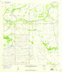
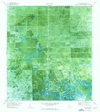
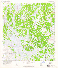 1958 Felda SE1959 Print · USGSIn the late 1950s, the border of Hendry and Collier counties remained a wet expanse of sloughs and hammocks. Local historians can trace the remote network of islands and drainage patterns, from the Keri Lookout Tower to the named reaches of Wild Cow Island and Lime Slough.2 unique versions available
 - 1958 Map of Goodno, 1959 Print
 1958 Goodno1959 Print · USGSThe Caloosahatchee River valley in the late fifties shows a landscape of cattle marshes and orange groves transitioning into managed water systems. Genealogists and historians can trace the community around Ortona, from the Ortona Cem and Indian Mound to the Old Railroad Grade.2 unique versions available
 - 1958 Map of Felda, 1959 Print
 1958 Felda1959 Print · USGSHendry County's marshy interior is shown in the late 1950s, a time when rail travel still centered on the Atlantic Coast Line. Researchers can locate community centers like Mt Zion Ch and the rail-stop at Felda (Station) amidst the Twelvemile Slough.3 unique versions available
 - 1958 Map of Sunniland, 1959 Print
 1958 Sunniland1959 Print · USGSCollier County's interior was a frontier of industry and swamp in the late fifties. You can trace the Atlantic Coast Line railroad past Sunniland to find several Oil Well sites and the archaeological marker of an Indian Mound.3 unique versions available
 - 1958 Map of Immokalee NE, 1959 Print
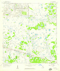
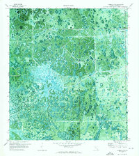
 1958 Immokalee NE1959 Print · USGSCollier and Hendry counties meet in this late 1950s survey of the Florida Everglades, showing a landscape defined by hammocks and wetlands. Researchers can trace the path of the Atlantic Coast Line railroad and locate the isolated settlement of Thorp.4 unique versions available
 - 1958 Map of Felda NE, 1959 Print
 1958 Felda NE1959 Print · USGSHendry County’s interior landscape during the late fifties reveals a mosaic of cypress sloughs and industrial transit corridors. Researchers can trace the path of the Atlantic Coast Line or find the remote Hunting Camp near the Old Railroad Grade.3 unique versions available
 - 1958 Map of Alva, 1959 Print
 1958 Alva1959 Print · USGSThe Caloosahatchee River corridor in the late fifties shows a landscape in transition from rural riverfront settlements to planned residential grids. Genealogists and historians can trace early footprints in Alva and Denaud or study the massive canal systems like Love Canal and Townsend Canal.4 unique versions available
 - 1958 Map of Sears, 1959 Print
 1958 Sears1959 Print · USGSHendry County at the end of the fifties reveals a landscape shaped by water management and expanding rail lines. Genealogists and historians can trace the tracks of the Atlantic Coast Line near Sears or locate the early footprint of the La Belle Airport.3 unique versions available
 - 1958 Map of La Belle, 1959 Print
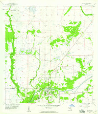 1958 La Belle1959 Print · USGSThe Hendry and Glades county line comes alive in the late fifties, centered on the riverfront community of La Belle. Researchers can trace the early street grid of La Belle and the winding course of Pollywog Creek and the Caloosahatchee River.3 unique versions available
 - 1958 Map of Alva SE, 1959 Print
 1958 Alva SE1959 Print · USGSFlorida's interior wetlands near the Lee and Hendry county line are shown here in the late fifties as early residential planning began to take hold. Genealogists and historians can trace the early grid of Lehigh Acres alongside landmarks like the Corkscrew Lookout Tower and Twelvemile Slough.3 unique versions available
 - 1970 Map of Moore Haven, 1976 Print
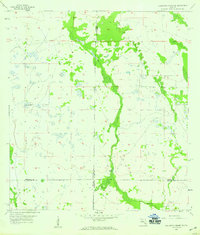
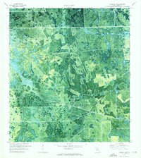
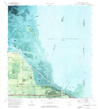
 1970 Moore Haven1976 Print · USGSThe northern edge of the Everglades comes into focus in the 1970s at the intersection of water and rail. Trace the historic layout of Moore Haven, its local landmarks like St Josephs Ch, and the vast Herbert Hoover Dyke system.2 unique versions available
 - 1970 Map of Lake Harbor SW, 1976 Print
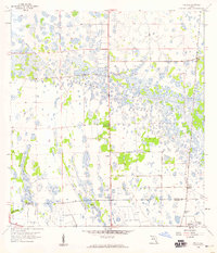
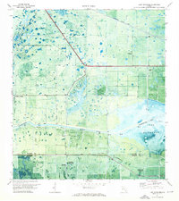
 1970 Lake Harbor SW1976 Print · USGSThe Hendry and Palm Beach borderlands in the 1970s reveal a landscape of intensive water management and wetland conversion. Researchers can trace the drainage network of the Bolles Canal past landmarks like Tonys Mound and Cowbone Hammock.
 - 1970 Map of Clewiston South, 1976 Print
 1970 Clewiston South1976 Print · USGSAs the Everglades' sugar industry matured in the early 1970s, this survey captured the engineered landscape south of Clewiston. Trace the rail-and-canal network through Sugar Junction and identify family-named sites like Hooker Point and Keela.2 unique versions available
 - 1970 Map of La Belle 4 SE, 1976 Print
 1970 La Belle 4 SE1976 Print · USGSHendry County's inland wetlands are captured at a moment of transition in the early 1970s. Researchers can trace the intersection of nature and development along Devils Garden Slough and early transit routes like Hill Grade Road.2 unique versions available
 - 1970 Map of La Belle 4 NW, 1976 Print
 1970 La Belle 4 NW1976 Print · USGSHendry County's landscape undergoes a transformation in the early seventies as agricultural drainage reaches into the wetlands. Genealogists and environmental historians can trace water management through Collins Slough and stations like the Pump and Radio Tower.2 unique versions available
 - 1970 Map of La Belle 4 NE, 1976 Print
 1970 La Belle 4 NE1976 Print · USGSHendry County at the start of the 1970s shows a landscape of developing agricultural tracts and natural wetlands. Researchers can locate specific infrastructure like Airglades Airport, the southern reaches of Hog Cypress, and scattered Pump stations.2 unique versions available
 - 1971 Map of La Belle 4 SW, 1976 Print
 1971 La Belle 4 SW1976 Print · USGSHendry County's subtropical wetlands are captured here in the early 1970s, revealing the complex hydrology of the Florida interior. Researchers can trace the natural boundaries of Graham Marsh and locate family-named landmarks like Tom Still Hammock.2 unique versions available
 - 1971 Map of Clewiston North, 1976 Print
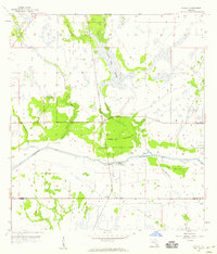
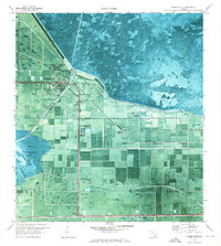
 1971 Clewiston North1976 Print · USGSThe southern shores of Lake Okeechobee are shown here in the early seventies as the town of Clewiston expanded along the dike. Local researchers can trace the developed grid of Clewiston, the location of the Ridgelawn Cem, and early marsh access via an Airboat Trail.3 unique versions available
 - 1971 Map of Lake Hicpochee, 1976 Print
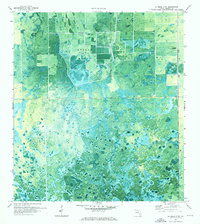
 1971 Lake Hicpochee1976 Print · USGSThe Florida Everglades transition from marsh to managed waterway in the early seventies, centered on the western shores of Lake Hicpochee. Researchers can trace the path of the Seaboard Coast Line and locate historic points like Citrus Center and an Indian Mound.
 - 1971 Map of Cochrans Pass, 1976 Print
 1971 Cochrans Pass1976 Print · USGSLake Okeechobee and its western marshlands are captured in high detail during the early 1970s. Trace the seasonal water patterns and historic navigation routes like Cochrans Pass, the Airboat Tr, and Moonshine Bay.
 - 1974 Map of Everglades 2 SW, 1976 Print
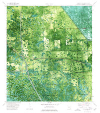 1974 Everglades 2 SW1976 Print · USGSThe Florida Everglades meet the interior wetlands during the mid-seventies in this detailed orthophotomap of the Big Cypress Seminole Indian Reservation. Researchers can locate community landmarks like Ahfachkee Day Sch and the site of Browns Indian Trading Post (Ruins) amidst the strands.2 unique versions available
Showing maps 1-25 of 39
Top cities of Hendry County
Frequently asked questions
- What are the different types of historical maps available for Hendry County?
- What is the oldest map of Hendry County?
- Where can I purchase historical maps of Hendry County for my home or office?
- Where can I download high-res historical maps of Hendry County?
- Are there historical topographic maps available for Hendry County?
- Is there historical aerial imagery available for Hendry County?
- Where are historical maps of Hendry County sourced from?