1970s Maps of Hillsborough County, Florida
Explore 12 historic maps of Hillsborough County from the 1970s. These maps offer a rare glimpse into what life looked like during the 1970s — showing old roads, neighborhoods, homes, and landmarks that have changed or disappeared over time.
Whether you're researching your family's past, planning a metal detecting trip, or studying how Hillsborough County's landscape evolved across the 1970s, these high-resolution maps are a powerful tool for exploring the history of this region.
- Focus on a specific era: All maps on this page are from the 1970s, giving you a focused view of this time period.
- See what’s changed: Compare century-old streets, trails, and buildings to today's modern landscape using overlays and satellite layers.
- Research with precision: Use these maps for genealogy, historical research, land use analysis, or educational projects.
- View, download, or print: Maps are fully viewable online in high resolution, and can be downloaded or printed for your own records.
Start exploring Hillsborough County's history through authentic maps from the 1970s. This is your window into the past.
Hillsborough County, FL maps
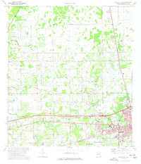
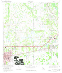
(12)- 1972 Map of Tampa, 1974 Print
 1972 Tampa1974 Print · USGSThe Florida Gulf Coast appears in a period of significant growth during the early seventies, from the urban centers of the bay to the quiet southern keys. Researchers can trace the expansion of St Petersburg or locate family sites near Safety Harbor, Valrico, and Boca Ciega.
 - 1973 Map of Wesley Chapel, 1976 Print
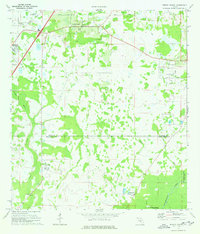 1973 Wesley Chapel1976 Print · USGSThe transition from citrus groves and ranch land to suburban communities in the 1970s is visible across the Wesley Chapel corridor. Genealogists and local historians can trace the early layout of Branchton, the grounds of Angus Valley Chapel, and the reaches of Cabbage Swamp.3 unique versions available
 - 1974 Map of Odessa, 1975 Print
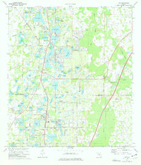
 1974 Odessa1975 Print · USGSThe lake-dotted borderlands of Pasco and Hillsborough counties come into focus in the mid-1970s. Trace the rural development of Odessa and its surrounding waters, from Indian Mounds near Mound Lake to the grounds of Camp Keystone and the Odessa Ch.4 unique versions available
 - 1974 Map of Elfers, 1975 Print
 1974 Elfers1975 Print · USGSThe West Florida coast in the mid-seventies shows a landscape in transition as suburbs replaced rural sloughs and bayous. Genealogists and historians can trace the growth of New Port Richey, locate several burial grounds like East Elfers Cem, and follow the Seaboard Coast Line through Seven Springs.2 unique versions available
 - 1974 Map of Oldsmar, 1976 Print
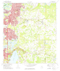
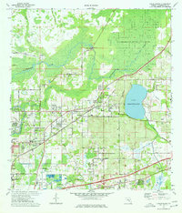
 1974 Oldsmar1976 Print · USGSCoastal Pinellas and Hillsborough counties are shown here in the mid-seventies as suburban growth began to surround the upper reaches of Old Tampa Bay. Genealogists and local historians can trace the development of Oldsmar, the grounds of Sylvan Abbey Memorial Park, and the ancient Indian Mound at Philippe Point.2 unique versions available
 - 1974 Map of Lutz, 1976 Print
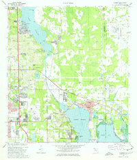
 1974 Lutz1976 Print · USGSThe Florida lake country on the Pasco and Hillsborough border is seen here in the mid-seventies, just as residential growth began to accelerate. Genealogists and local historians can locate Sanders Memorial School, Tims Memorial Church, and the winding Seaboard Coast Line rail line.3 unique versions available
 - 1974 Map of Thonotosassa, 1977 Print
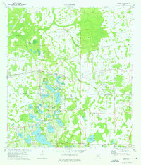
 1974 Thonotosassa1977 Print · USGSThis mid-1970s survey captures the area around Lake Thonotosassa as suburban growth began to meet rural citrus groves. Researchers can locate local landmarks like the Golden Gate Speedway, trace the Seaboard Coast Line, and find family-named churches like Marshall Ch.2 unique versions available
 - 1975 Map of Socrum, 1976 Print
 1975 Socrum1976 Print · USGSThe rural marshlands and timber country where Polk, Pasco, and Hillsborough counties meet are captured here during the mid-seventies. Local historians can trace family-named roads like Keen Road and Raulerson Road near small settlements such as Socrum and Kathleen.3 unique versions available
 - 1975 Map of Zephyrhills, 1976 Print
 1975 Zephyrhills1976 Print · USGSMid-century growth in Pasco County is on full display here as the town of Zephyrhills expands amid its citrus groves and wetlands. Genealogists and local historians can trace the foundations of the community through landmarks like West Zephyrhills Sch, Geiger Cem, and the Seaboard Coast Line railroad.3 unique versions available
 - 1975 Map of Plant City West, 1977 Print
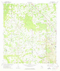
 1975 Plant City West1977 Print · USGSHillsborough County's interior comes to life in the mid-seventies, centered on the western expansion of a growing citrus and rail hub. Genealogists and local historians can trace the foundations of the community at Plant City and find rural landmarks like Cork Academy and Bethlehem Cem.3 unique versions available
 - 1975 Map of Plant City East, 1977 Print
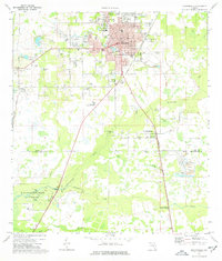
 1975 Plant City East1977 Print · USGSFlorida's phosphate country and the growth of Plant City are captured here in the mid-seventies, just as suburban expansion met industrial extraction. Trace family roots and local history at Oaklawn Cem, the strip mines near Youmans, or the Winston Sch.3 unique versions available
 - 1978 Map of Tarpon Springs, 1982 Print
 1978 Tarpon Springs1982 Print · USGSCoastal Florida is shown during its late-century period of rapid growth, from the Gulf shores to the deep inland swamps. Researchers can trace the development of the Intracoastal Waterway and locate regional landmarks like the Anclote Missile Tracking Annex and Lake Tarpon.
End of results
Showing maps 1-12 of 12
Top cities of Hillsborough County
- Tampa historical maps
- Brandon historical maps
- Riverview historical maps
- Plant City historical maps
- Temple Terrace historical maps
- Lutz historical maps
Frequently asked questions
- What are the different types of historical maps available for Hillsborough County?
- What is the oldest map of Hillsborough County?
- Where can I purchase historical maps of Hillsborough County for my home or office?
- Where can I download high-res historical maps of Hillsborough County?
- Are there historical topographic maps available for Hillsborough County?
- Is there historical aerial imagery available for Hillsborough County?
- Where are historical maps of Hillsborough County sourced from?