Old Maps of Hillsborough County, Florida for Metal Detecting
Plan your next treasure hunt with 274 historic maps of Hillsborough County. Find old homesites, ghost towns, trails, and gathering spots that may be lost to time — perfect for identifying promising metal detecting locations.
- Locate forgotten sites: Uncover places like long-lost settlements, abandoned rail lines, or gathering spots.
- Plan better hunts: Use map overlays combined with LiDAR or satellite views to narrow in on historically rich areas.
- Made for detectorists: Thousands of hobbyists use these maps to discover relics, coins, and hidden history.
Use these historic maps to boost your research and find new opportunities beneath the surface of Hillsborough County.
Hillsborough County, FL maps
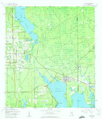
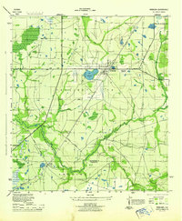
(274)- 1921 Map of Tampa
 1921 Tampa1921 Print · USGSCoastal Florida in the early twenties shows a landscape of growing towns and deep-water ports linked by expanding railroads. Genealogists and local historians can trace the early footprints of Ybor City, locate the Turpentine Still near Limona, and follow old routes like Bull Frog Road.
 - 1921 Map of Fort De Soto
 1921 Fort De Soto1921 Print · USGSThe Florida coast at the start of the twenties reveals a landscape of isolated military outposts and emerging rail towns along the Gulf. Genealogists and historians can trace early families in Bradentown, locate the U.S. Quarantine Station, and follow the Seaboard Air Line tracks.2 unique versions available
 - 1921 Map of St Petersburg
 1921 St Petersburg1921 Print · USGSThe Pinellas Peninsula just after the First World War shows a world of mangrove swamps, tidal bayous, and emerging settlements. Genealogists and local historians can trace early neighborhood footprints and coastal landmarks from Pinellas Park and Lealman to the growing streets of St. Petersburg.2 unique versions available
 - 1942 Map of Cockroach Bay
 1942 Cockroach Bay1942 Print · USGSThe eastern shores of Tampa Bay are captured here in the early 1940s, highlighting the undeveloped coastal wetlands and islands of the region. Researchers can trace early infrastructure and landmarks such as the Big Cockroach Mound, the Atlantic Coast Line rail corridor, and the small community at Piney Point.
 - 1943 Map of Gandy Bridge
 1943 Gandy Bridge1943 Print · USGSHillsborough County's shoreline during the wartime mobilization shows a landscape of military ranges and emerging suburbs. Trace the development of Beach Park, the footprint of Drew Field, and the rail infrastructure of the Atlantic Coast Line.
 - 1943 Map of Pass-A-Grille
 1943 Pass-A-Grille1943 Print · USGSCoastal Pinellas County comes into focus during the war years, revealing a landscape of nascent beach communities and protected island refuges. Trace the early footprints of Don Cesar Beach and Lakewood Estates, or locate the historic Piney Point Ferry landing.
 - 1943 Map of Safety Harbor
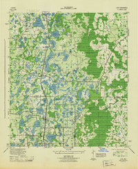
 1943 Safety Harbor1943 Print · USGSThe Pinellas County coast in the early 1940s is captured here during a period of wartime growth and coastal development. Genealogists and historians can trace old homesteads near Coachman, the expansion of Pinellas Army Airfield, and the route of the Davis Causeway.
 - 1943 Map of Port Tampa
 1943 Port Tampa1943 Print · USGSThe Tampa Bay shoreline during World War II reveals a mix of wartime military expansion and early suburban development. Genealogists and historians can trace the foundations of Snell Isle, the industrial works at Port Tampa, and the early layout of MacDill Field.
 - 1943 Map of Odessa, 1957 Print
 1943 Odessa1957 Print · USGSCoastal Florida pinelands and transit corridors emerge in this mid-century survey of the Pasco and Hillsborough county line. Trace the steam-era rail history through Odessa at the Atlantic Coast Line junction and explore the lakefronts of Keystone Lake and Camp Mawian.3 unique versions available
 - 1943 Map of Elfers, 1957 Print
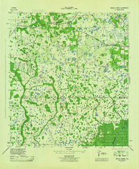
 1943 Elfers1957 Print · USGSThe Florida Gulf Coast comes alive in the 1940s as settlements like New Port Richey and Tarpon Springs begin to take shape. Genealogists and researchers can trace the historic Dixie Highway and locate rural landmarks such as Elfers and Seven Springs.2 unique versions available
 - 1943 Map of Thonotosassa, 1961 Print
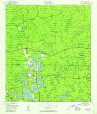
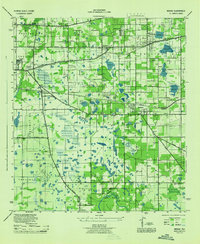
 1943 Thonotosassa1961 Print · USGSHillsborough County's landscape during the 1940s is defined by citrus groves and river wetlands centered around the massive Lake Thonotosassa. Researchers can trace old transportation routes and local landmarks like the Indian Sch, Missionary Ch, and the Hillsborough County Railroad.2 unique versions available
 - 1943 Map of Lutz, 1961 Print
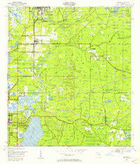
 1943 Lutz1961 Print · USGSThe central Florida lake country comes into focus in the early 1940s as the rail-driven settlements of Lutz and Land O'Lakes began to take shape. Researchers can trace the early layout of Dupree Gardens, local churches like Drexel Ch, and the twin corridors of the Atlantic Coast Line and Seaboard Air Line.2 unique versions available
 - 1943 Map of Oldsmar, 1961 Print
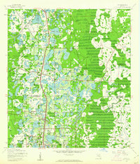
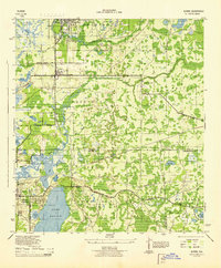
 1943 Oldsmar1961 Print · USGSUpper Pinellas County was a quiet region of citrus groves and coastal inlets during the early 1940s. Genealogists and historians can trace old community centers like Curlew, locate the Curlew Ch, and see the early layout of Oldsmar along the Seaboard Air Line railroad.2 unique versions available
 - 1944 Map of Sulphur Springs
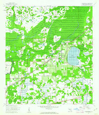
 1944 Sulphur Springs1944 Print · USGSNorth of Tampa during the mid-forties, this area shows a landscape of citrus groves and lakefront settlements before the post-war building boom. Genealogists can trace family roots through Lake Magdalene Cem, Oak Grove School, and the early streets of Sulphur Springs.
 - 1944 Map of Egmont Key
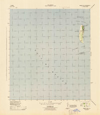 1944 Egmont Key1944 Print · USGSEgmont Key served as a critical coastal defense and navigational hub during the mid-forties. Historians can trace specific World War II era military and maritime sites, including the Rifle Range, the Egmont Key Lt Ho, and the Casemate.2 unique versions available
 - 1944 Map of Plant City
 1944 Plant City1944 Print · USGSMid-century Hillsborough and Polk counties are captured here during a time of significant military activity. Researchers can find old Florida landmarks like Enon Church, the Winston School, and the wartime footprints of Drane Field US Army.2 unique versions available
 - 1944 Map of Mango
 1944 Mango1944 Print · USGSHillsborough County's interior settlements and agricultural lands are captured here during the mid-forties. Researchers can trace family history through sites like St Marys Ch and Cem, the Levin Armwood School, and the early rail stops at Seffner and Mango.
 - 1944 Map of Anna Maria
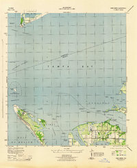 1944 Anna Maria1944 Print · USGSCoastal Manatee County is captured during the mid-forties, showing the early layout of Anna Maria and the mainland groves of Palma Sola. Trace the old shoreline landmarks from the Municipal Pier to the ancient Portavant Mound and the isolated Passage Key.2 unique versions available
 - 1944 Map of Ruskin
 1944 Ruskin1944 Print · USGSThe Florida coast south of Tampa during the mid-forties reveals a complex network of bayous and early road development. Genealogists and historians can trace the foundations of Ruskin and Sun City or locate the Ruskin Cem along the Little Manatee River.
 - 1944 Map of Tampa
 1944 Tampa1944 Print · USGSTampa and the surrounding bayfront neighborhoods are shown during the mid-forties, capturing the city's transition into a modern maritime hub. Trace historical property lines and landmarks like Ybor City, Davis Islands, and the Peter O Knight Municipal Airport.
 - 1944 Map of Wimauma
 1944 Wimauma1944 Print · USGSMid-century Hillsborough County comes into focus as a landscape of citrus groves and pine flatwoods defined by the Seaboard Air Line. Trace the early development of Wimauma and its local landmarks like Moody Pond and the Wimauma Airport.
 - 1944 Map of Wesley Chapel
 1944 Wesley Chapel1944 Print · USGSPasco and Hillsborough counties are shown during the mid-forties, characterized by scattered rural settlements and a dense network of creeks and cypress swamps. Researchers can trace the original locations of Wesley Chapel, Double Branch Church, and the Sulphur Works along the river banks.3 unique versions available
 - 1944 Map of Elfers
 1944 Elfers1944 Print · USGSThe Florida Gulf coast comes into focus during the mid-1940s as the communities of New Port Richey and Elfers begin to expand. Genealogists and local historians can trace family locations near Seven Springs, the Anclote River, and early rail lines like the Seaboard Air Line.
 - 1944 Map of Lutz
 1944 Lutz1944 Print · USGSFlorida's lake-strewn interior comes alive in the mid-1940s, showing the early rail and road networks of northern Hillsborough County. Genealogists and historians can trace the foundations of Lutz and Drexel, locating essential local landmarks like the Myrtle Denham School and the Drexel Station along the Atlantic Coast Line.
 - 1944 Map of Oldsmar
 1944 Oldsmar1944 Print · USGSCoastal Pinellas and Hillsborough counties are shown here during the Second World War as the region's citrus and rail economy began to meet modern highway expansion. Genealogists and local historians can locate early landmarks like Curlew Ch, the Indian Mounds, and the Seaboard Air Line corridor.
Showing maps 1-25 of 274
Top cities of Hillsborough County
- Tampa historical maps
- Brandon historical maps
- Riverview historical maps
- Plant City historical maps
- Temple Terrace historical maps
- Lutz historical maps
Frequently asked questions
- What are the different types of historical maps available for Hillsborough County?
- What is the oldest map of Hillsborough County?
- Where can I purchase historical maps of Hillsborough County for my home or office?
- Where can I download high-res historical maps of Hillsborough County?
- Are there historical topographic maps available for Hillsborough County?
- Is there historical aerial imagery available for Hillsborough County?
- Where are historical maps of Hillsborough County sourced from?