1940s Maps of Amanda, Florida
Explore 2 historic maps of Amanda from the 1940s. These maps offer a rare glimpse into what life looked like during the 1940s — showing old roads, neighborhoods, homes, and landmarks that have changed or disappeared over time.
Whether you're researching your family's past, planning a metal detecting trip, or studying how Amanda's landscape evolved across the 1940s, these high-resolution maps are a powerful tool for exploring the history of this region.
- Focus on a specific era: All maps on this page are from the 1940s, giving you a focused view of this time period.
- See what’s changed: Compare century-old streets, trails, and buildings to today's modern landscape using overlays and satellite layers.
- Research with precision: Use these maps for genealogy, historical research, land use analysis, or educational projects.
- View, download, or print: Maps are fully viewable online in high resolution, and can be downloaded or printed for your own records.
Start exploring Amanda's history through authentic maps from the 1940s. This is your window into the past.
Amanda, FL maps
(2)- 1944 Map of Ruskin
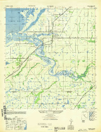
 1944 Ruskin1944 Print · USGSThe Florida coast south of Tampa during the mid-forties reveals a complex network of bayous and early road development. Genealogists and historians can trace the foundations of Ruskin and Sun City or locate the Ruskin Cem along the Little Manatee River.
 - 1947 Map of Ruskin
 1947 Ruskin1947 Print · USGSCoastal Hillsborough and Manatee counties come into focus during the mid-forties, showing the developing settlements along the eastern bay. Genealogists and historians can trace old homesteads and landmarks near Ruskin, the Sun City Sch, and the winding Little Manatee River.
End of results
Showing maps 1-2 of 2
Top cities near Amanda
- Tampa historical maps
- Saint Petersburg historical maps
- Riverview historical maps
- Bradenton historical maps
- Palmetto historical maps
- Feather Sound historical maps
Frequently asked questions
- What are the different types of historical maps available for Amanda?
- What is the oldest map of Amanda?
- Where can I purchase historical maps of Amanda for my home or office?
- Where can I download high-res historical maps of Amanda?
- Are there historical topographic maps available for Amanda?
- Is there historical aerial imagery available for Amanda?
- Where are historical maps of Amanda sourced from?