1940s Maps of Lutz, Florida
Explore 9 historic maps of Lutz from the 1940s. These maps offer a rare glimpse into what life looked like during the 1940s — showing old roads, neighborhoods, homes, and landmarks that have changed or disappeared over time.
Whether you're researching your family's past, planning a metal detecting trip, or studying how Lutz's landscape evolved across the 1940s, these high-resolution maps are a powerful tool for exploring the history of this region.
- Focus on a specific era: All maps on this page are from the 1940s, giving you a focused view of this time period.
- See what’s changed: Compare century-old streets, trails, and buildings to today's modern landscape using overlays and satellite layers.
- Research with precision: Use these maps for genealogy, historical research, land use analysis, or educational projects.
- View, download, or print: Maps are fully viewable online in high resolution, and can be downloaded or printed for your own records.
Start exploring Lutz's history through authentic maps from the 1940s. This is your window into the past.
Lutz, FL maps
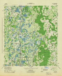
(9)- 1943 Map of Odessa, 1957 Print
 1943 Odessa1957 Print · USGSCoastal Florida pinelands and transit corridors emerge in this mid-century survey of the Pasco and Hillsborough county line. Trace the steam-era rail history through Odessa at the Atlantic Coast Line junction and explore the lakefronts of Keystone Lake and Camp Mawian.3 unique versions available
 - 1943 Map of Lutz, 1961 Print
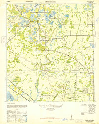
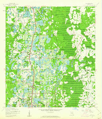 1943 Lutz1961 Print · USGSThe central Florida lake country comes into focus in the early 1940s as the rail-driven settlements of Lutz and Land O'Lakes began to take shape. Researchers can trace the early layout of Dupree Gardens, local churches like Drexel Ch, and the twin corridors of the Atlantic Coast Line and Seaboard Air Line.2 unique versions available
 - 1944 Map of Sulphur Springs
 1944 Sulphur Springs1944 Print · USGSNorth of Tampa during the mid-forties, this area shows a landscape of citrus groves and lakefront settlements before the post-war building boom. Genealogists can trace family roots through Lake Magdalene Cem, Oak Grove School, and the early streets of Sulphur Springs.
 - 1944 Map of Lutz
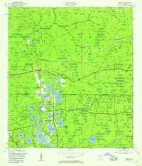
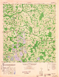
 1944 Lutz1944 Print · USGSFlorida's lake-strewn interior comes alive in the mid-1940s, showing the early rail and road networks of northern Hillsborough County. Genealogists and historians can trace the foundations of Lutz and Drexel, locating essential local landmarks like the Myrtle Denham School and the Drexel Station along the Atlantic Coast Line.
 - 1944 Map of Odessa
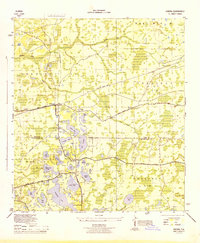 1944 Odessa1944 Print · USGSMid-century Pasco and Hillsborough counties are shown here as a landscape of citrus groves, rail lines, and cypress swamps. Genealogists and historians can trace the footprint of early communities at Odessa and Lake Fern, or find landmarks like the Lake Fern School and Camp Mawian YMCA.
 - 1945 Map of Sulphur Springs
 1945 Sulphur Springs1945 Print · USGSHillsborough County's northern suburbs and lake districts emerge in the mid-1940s as the riverfront expands toward the citrus groves. Genealogists and historians can locate the Lake Carrol Cem, trace the Atlantic Coast Line tracks, or find the early airfield at Henderson-Hillsborough International Airport.
 - 1947 Map of Citrus Park
 1947 Citrus Park1947 Print · USGSNorthwest of Tampa in the late Forties, this area reveals a landscape of citrus groves and cypress swamps transitioning into a military and utility hub. Genealogists and local historians can trace old settlements like Mullis City, find the Keystone Church, or locate the St Petersburg Water Supply facility.
 - 1949 Map of Sulphur Springs
 1949 Sulphur Springs1949 Print · USGSHillsborough County in the late 1940s shows the growth of Sulphur Springs and Tampa northward into a lake-filled landscape. Researchers can find old community hubs like Oak Grove School, the Lake-Carrol Cem, and the early footprint of the Henderson-Hillsborough International Airport.
 - 1949 Map of Odessa
 1949 Odessa1949 Print · USGSThe interior of the Florida Gulf Coast is shown here in the late 1940s, a landscape defined by citrus groves and sprawling lake networks. Genealogists and local historians can trace the early community hubs of Odessa and Lake Fern, including the Lake Fern School and the Atlantic Coast Line rail corridor.
End of results
Showing maps 1-9 of 9
Top cities near Lutz
- Tampa historical maps
- Saint Petersburg historical maps
- Brandon historical maps
- Temple Terrace historical maps
- Oldsmar historical maps
- Dade City historical maps
See more
Top neighborhoods of Lutz
- Apex Lake Estates historical maps
- Deer Park historical maps
- Greer Ranch historical maps
- Southern Acres historical maps
- Cullaro historical maps
Frequently asked questions
- What are the different types of historical maps available for Lutz?
- What is the oldest map of Lutz?
- Where can I purchase historical maps of Lutz for my home or office?
- Where can I download high-res historical maps of Lutz?
- Are there historical topographic maps available for Lutz?
- Is there historical aerial imagery available for Lutz?
- Where are historical maps of Lutz sourced from?