1940s Maps of Hillsborough Heights East, Tampa
Explore 2 historic maps of Hillsborough Heights East from the 1940s. These maps offer a rare glimpse into what life looked like during the 1940s — showing old roads, neighborhoods, homes, and landmarks that have changed or disappeared over time.
Whether you're researching your family's past, planning a metal detecting trip, or studying how Hillsborough Heights East's landscape evolved across the 1940s, these high-resolution maps are a powerful tool for exploring the history of this region.
- Focus on a specific era: All maps on this page are from the 1940s, giving you a focused view of this time period.
- See what’s changed: Compare century-old streets, trails, and buildings to today's modern landscape using overlays and satellite layers.
- Research with precision: Use these maps for genealogy, historical research, land use analysis, or educational projects.
- View, download, or print: Maps are fully viewable online in high resolution, and can be downloaded or printed for your own records.
Start exploring Hillsborough Heights East's history through authentic maps from the 1940s. This is your window into the past.
Hillsborough Heights East, Tampa maps
(2)- 1944 Map of Tampa
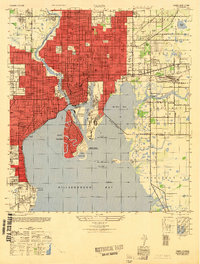
 1944 Tampa1944 Print · USGSTampa and the surrounding bayfront neighborhoods are shown during the mid-forties, capturing the city's transition into a modern maritime hub. Trace historical property lines and landmarks like Ybor City, Davis Islands, and the Peter O Knight Municipal Airport.
 - 1947 Map of Tampa
 1947 Tampa1947 Print · USGSTampa and its harbor districts appear here in the late Forties as the city's rail and maritime industries reached a mid-century peak. Genealogists and historians can trace the old street grids of Ybor City, locate family plots in Rose Hill Cem, and see early aviation at Peter O Knight Municipal Airport.2 unique versions available
End of results
Showing maps 1-2 of 2
Top cities near Hillsborough Heights East
- Tampa historical maps
- Saint Petersburg historical maps
- Brandon historical maps
- Riverview historical maps
- Temple Terrace historical maps
- Lutz historical maps
See more
Frequently asked questions
- What are the different types of historical maps available for Hillsborough Heights East?
- What is the oldest map of Hillsborough Heights East?
- Where can I purchase historical maps of Hillsborough Heights East for my home or office?
- Where can I download high-res historical maps of Hillsborough Heights East?
- Are there historical topographic maps available for Hillsborough Heights East?
- Is there historical aerial imagery available for Hillsborough Heights East?
- Where are historical maps of Hillsborough Heights East sourced from?