1900s (20th Century) Maps of Grand Ridge, Florida
Explore 12 historic maps of Grand Ridge from the 1900s (20th Century). These maps offer a rare glimpse into what life looked like during the 1900s — showing old roads, neighborhoods, homes, and landmarks that have changed or disappeared over time.
Whether you're researching your family's past, planning a metal detecting trip, or studying how Grand Ridge's landscape evolved across the 1900s, these high-resolution maps are a powerful tool for exploring the history of this region.
- Focus on a specific era: All maps on this page are from the 1900s, giving you a focused view of this time period.
- See what’s changed: Compare century-old streets, trails, and buildings to today's modern landscape using overlays and satellite layers.
- Research with precision: Use these maps for genealogy, historical research, land use analysis, or educational projects.
- View, download, or print: Maps are fully viewable online in high resolution, and can be downloaded or printed for your own records.
Start exploring Grand Ridge's history through authentic maps from the 1900s. This is your window into the past.
Grand Ridge, FL maps
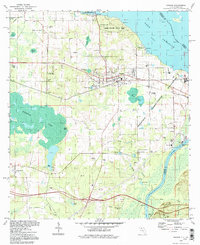
(12)- 1952 Map of Cypress, 1953 Print
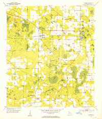 1952 Cypress1953 Print · USGSJackson County in the early fifties shows a landscape of rail-side towns and scattered rural homesteads defined by its unique cypress wetlands. Genealogists can trace family names through numerous landmarks like Logan Cemetery, Antioch Church, and Strickland Lake.
 - 1954 Map of Sneads, 1955 Print
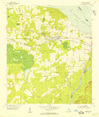 1954 Sneads1955 Print · USGSSneads and the surrounding Jackson County bottomlands are captured here in the mid-1950s as the riverfront landscape was being reshaped by the Jim Woodruff Reservoir. Researchers can trace family-named sites and rural institutions like Inwood Ch, Pope Cem, and the Grand Ridge Lookout Tower.2 unique versions available
 - 1954 Map of Tallahassee, 1967 Print
 1954 Tallahassee1967 Print · USGSThe Florida Panhandle and South Georgia are captured here during a period of mid-century growth and military expansion. Researchers can trace the development of Panama City, the footprint of Tyndall Air Force Base, and the rail lines of the Atlantic Coast Line.4 unique versions available
 - 1959 Map of Tallahassee
 1959 Tallahassee1959 Print · USGSFlorida's Panhandle and the Big Bend region appear here in the mid-fifties, showing a landscape defined by its great river systems and developing coast. Trace the early layout of Panama City, the expansive Apalachicola National Forest, and the coastal St Marks Lighthouse.
 - 1960 Map of Tallahassee
 1960 Tallahassee1960 Print · USGSThe Florida Panhandle and southern Georgia are captured here in the mid-twentieth century, showing a region defined by its rivers and military installations. Genealogists and historians can trace the growth of Tallahassee or locate coastal landmarks like the St Marks Lighthouse and Tyndall Air Force Base.
 - 1978 Map of Bainbridge, 1980 Print
 1978 Bainbridge1980 Print · USGSIn the late seventies, this Georgia-Florida borderland was defined by the confluence of the Flint and Chattahoochee rivers. Trace the region's infrastructure via the Seaboard Coast Line Railroad and find sites like Bainbridge State Hospital.
 - 1979 Map of Marianna, 1980 Print
 1979 Marianna1980 Print · USGSFlorida's northern panhandle and the neighboring Alabama-Georgia borderlands are captured here in the late seventies. Genealogists and local historians can trace family roots through settlements like Graceville and Cottondale or follow the historic Louisville and Nashville rail lines.2 unique versions available
 - 1982 Map of Sneads
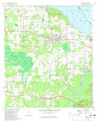 1982 Sneads1982 Print · USGSThe Florida-Georgia borderlands come to life in this early 1980s record of Jackson County, where the massive reservoir meets the winding river system. Genealogists and local historians can trace family sites at Yan Cem and Sinai Cem or locate the infrastructure of Sneads and Grand Ridge.
 - 1982 Map of Cypress, 1983 Print
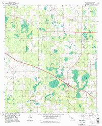
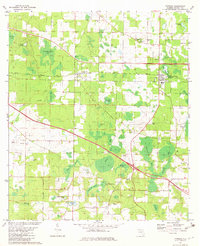 1982 Cypress1983 Print · USGSJackson County's rural character is on full display in the early eighties, centered on the historic rail corridor between Cypress and Grand Ridge. Genealogists and local historians can trace legacy landmarks like Providence Ch, Logan Cem, and Lake Finney.
 - 1988 Map of Tallahassee
 1988 Tallahassee1988 Print · USGSThe Florida Panhandle and South Georgia are captured here in the late eighties, showing the expansion of the regional highway network and coastal growth. Genealogists and historians can trace rail lines like the Seaboard System Railroad or locate family roots in Blountstown, Graceville, or Crawfordville.2 unique versions available
 - 1994 Map of Sneads, 1998 Print
 1994 Sneads1998 Print · USGSJackson County, Florida, is captured here in the 1990s as a vital crossroads of river commerce and state conservation. Researchers can trace historic family burial sites and local congregations including Sardis Cem, St Peter Cem, and Sinai Ch.
 - 1994 Map of Cypress, 1998 Print
 1994 Cypress1998 Print · USGSJackson County in the 1990s remained a landscape of quiet crossroads and extensive wetlands. Researchers can trace family history through numerous small burial grounds like Stephens Cem or locate rural centers such as Grand Ridge and Cypress.
End of results
Showing maps 1-12 of 12
Top cities near Grand Ridge
- Marianna historical maps
- Chattahoochee historical maps
- Sneads historical maps
- Greenwood historical maps
- Altha historical maps
Frequently asked questions
- What are the different types of historical maps available for Grand Ridge?
- What is the oldest map of Grand Ridge?
- Where can I purchase historical maps of Grand Ridge for my home or office?
- Where can I download high-res historical maps of Grand Ridge?
- Are there historical topographic maps available for Grand Ridge?
- Is there historical aerial imagery available for Grand Ridge?
- Where are historical maps of Grand Ridge sourced from?