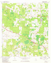
1982 Map of Cypress
USGS Topo · Published 1983About this map
Cypress and Grand Ridge stand as the primary settlements in this Jackson County landscape, clustered along the historic Louisville and Nashville rail line. The region is defined by a complex network of wetlands and shallow waters, including the expansive Ocheesee Pond to the east and numerous distinct basins like Scott Hammock Pond and Cook Smokehouse Pond. This 1982 map reveals a rural community deeply rooted in its local geography, where small family cemeteries and country churches serve as landmarks. Genealogy researchers will find several named burial sites, including Stephens Cem and Logan Cem, alongside spiritual centers such as Providence Ch and Midway Ch. The presence of several industrial sites, including a sandpit and claypit, reflects the local extraction economy operating amidst the interconnected sloughs and bays that dominate the central terrain.
Find a feature on this map
45 named features on this map. Tap any name to fly to it.
Don’t see what you’re looking for? This feature index may not catch every label — zoom into the map to look around manually.
Map Details
Editions of this 1982 Cypress Map
This is the sole edition of this map. No revisions or reprints were ever made.
Other maps of this area

1952 · Cypress
USGS Topo · 1:24,000

1952 · Oakdale
USGS Topo · 1:24,000

1952 · Dellwood
USGS Topo · 1:24,000

1952 · Altha West
USGS Topo · 1:24,000

1952 · Altha East
USGS Topo · 1:24,000

1952 · Marianna
USGS Topo · 1:24,000

1954 · Sneads
USGS Topo · 1:24,000

1954 · Tallahassee
USGS Topo · 1:250,000

1955 · Fairchild
USGS Topo · 1:24,000

1955 · Rock Bluff
USGS Topo · 1:24,000