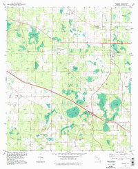
1994 Map of Cypress
USGS Topo · Published 1998About this map
Grand Ridge and Cypress anchor this part of Jackson County, where the landscape is defined by an intricate network of wetlands, ponds, and sloughs. The terrain transitions from the low-lying Williams Slough and Ocheesee Pond to several named high points like Honey Hill. This map reflects the enduring rural character of the Florida Panhandle in the late 20th century, showing numerous small churches such as Antioch Ch and Shady Grove Ch that served the surrounding agricultural and timber communities.
Find a feature on this map
44 named features on this map. Tap any name to fly to it.
Don’t see what you’re looking for? This feature index may not catch every label — zoom into the map to look around manually.
Map Details
Editions of this 1994 Cypress Map
This is the sole edition of this map. No revisions or reprints were ever made.
Other maps of this area

1952 · Cypress
USGS Topo · 1:24,000

1952 · Oakdale
USGS Topo · 1:24,000

1952 · Dellwood
USGS Topo · 1:24,000

1952 · Altha West
USGS Topo · 1:24,000

1952 · Altha East
USGS Topo · 1:24,000

1952 · Marianna
USGS Topo · 1:24,000

1954 · Sneads
USGS Topo · 1:24,000

1954 · Tallahassee
USGS Topo · 1:250,000

1955 · Fairchild
USGS Topo · 1:24,000

1955 · Rock Bluff
USGS Topo · 1:24,000