1900s (20th Century) Maps of Woodville, Florida
Explore 8 historic maps of Woodville from the 1900s (20th Century). These maps offer a rare glimpse into what life looked like during the 1900s — showing old roads, neighborhoods, homes, and landmarks that have changed or disappeared over time.
Whether you're researching your family's past, planning a metal detecting trip, or studying how Woodville's landscape evolved across the 1900s, these high-resolution maps are a powerful tool for exploring the history of this region.
- Focus on a specific era: All maps on this page are from the 1900s, giving you a focused view of this time period.
- See what’s changed: Compare century-old streets, trails, and buildings to today's modern landscape using overlays and satellite layers.
- Research with precision: Use these maps for genealogy, historical research, land use analysis, or educational projects.
- View, download, or print: Maps are fully viewable online in high resolution, and can be downloaded or printed for your own records.
Start exploring Woodville's history through authentic maps from the 1900s. This is your window into the past.
Woodville, FL maps
(8)- 1954 Map of Woodville, 1956 Print
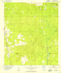 1954 Woodville1956 Print · USGSThe Leon and Wakulla county line area in the mid-1950s reveals a landscape defined by the karst hydrology of the St Marks River. Local historians can trace the paths of the Seaboard Air Line railroad and locate old family burial grounds like Rhodes Cem and Godwin Cem.2 unique versions available
 - 1954 Map of Tallahassee, 1967 Print
 1954 Tallahassee1967 Print · USGSThe Florida Panhandle and South Georgia are captured here during a period of mid-century growth and military expansion. Researchers can trace the development of Panama City, the footprint of Tyndall Air Force Base, and the rail lines of the Atlantic Coast Line.4 unique versions available
 - 1959 Map of Tallahassee
 1959 Tallahassee1959 Print · USGSFlorida's Panhandle and the Big Bend region appear here in the mid-fifties, showing a landscape defined by its great river systems and developing coast. Trace the early layout of Panama City, the expansive Apalachicola National Forest, and the coastal St Marks Lighthouse.
 - 1960 Map of Tallahassee
 1960 Tallahassee1960 Print · USGSThe Florida Panhandle and southern Georgia are captured here in the mid-twentieth century, showing a region defined by its rivers and military installations. Genealogists and historians can trace the growth of Tallahassee or locate coastal landmarks like the St Marks Lighthouse and Tyndall Air Force Base.
 - 1979 Map of Tallahassee, 1980 Print
 1979 Tallahassee1980 Print · USGSFlorida's capital and the Gulf coast are captured here in the late seventies, showing the region's balance between urban growth and massive protected wetlands. Researchers can trace the routes of the Apalachicola Northern Railroad or locate small inland hubs like Sopchoppy, Panacea, and Hosford.
 - 1981 Map of Woodville, 1982 Print
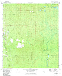 1981 Woodville1982 Print · USGSThe Leon and Wakulla county borderlands are shown here in the early eighties, centered on the historic site of the Natural Bridge Battlefield. Trace the path of the Seaboard Coast Line or locate family markers at Rhodes Cem and Godwin Cem.2 unique versions available
 - 1988 Map of Tallahassee
 1988 Tallahassee1988 Print · USGSThe Florida Panhandle and South Georgia are captured here in the late eighties, showing the expansion of the regional highway network and coastal growth. Genealogists and historians can trace rail lines like the Seaboard System Railroad or locate family roots in Blountstown, Graceville, or Crawfordville.2 unique versions available
 - 1999 Map of Woodville, 2003 Print
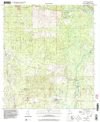 1999 Woodville2003 Print · USGSThe Leon County pine woods and springs are documented here at the close of the twentieth century. Researchers can trace the Forbes Purchase Line and locate local landmarks like Rhodes Cem and the Natural Bridge Battlefield State Historic Site.
End of results
Showing maps 1-8 of 8
Top cities near Woodville
- Tallahassee historical maps
- Crawfordville historical maps
- Midway historical maps
- Saint Marks historical maps
Frequently asked questions
- What are the different types of historical maps available for Woodville?
- What is the oldest map of Woodville?
- Where can I purchase historical maps of Woodville for my home or office?
- Where can I download high-res historical maps of Woodville?
- Are there historical topographic maps available for Woodville?
- Is there historical aerial imagery available for Woodville?
- Where are historical maps of Woodville sourced from?