
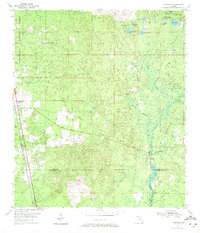
1954 Map of Woodville
USGS Topo · Published 1956About this map
Natural Bridge stands as a focal point in this mid-century survey of the Florida panhandle, where the St Marks River vanishes into a series of sinks and springs. The landscape is defined by the historic Forbes Purchase Line, a legacy of colonial-era land grants that still dictated property boundaries in the 1950s. To the west, the Apalachicola National Forest covers large tracts of timberland, while the Seaboard Air Line railroad provides a vital transportation corridor through the settlements of Woodville and Vereen. Genealogists may find interest in local burial sites such as Rhodes Cem and Godwin Cem, which are tucked away near the winding courses of Hamlin Branch and Chicken Branch. The map captures a transition between the organized settlement at Woodville and the karst topography of the river basin, featuring numerous named ponds like Lutterloh Pond and Turf Pond.
Find a feature on this map
30 named features on this map. Tap any name to fly to it.
Don’t see what you’re looking for? This feature index may not catch every label — zoom into the map to look around manually.
Map Details
Editions of this 1954 Woodville Map
2 editions found
Other maps of this area

1940 · Tallahassee
USGS Topo · 1:62,500

1940 · Arran
USGS Topo · 1:62,500

1942 · Tallahassee
USGS Topo · 1:62,500

1943 · Arran
USGS Topo · 1:62,500

1943 · Tallahassee
USGS Topo · 1:62,500

1954 · Lloyd
USGS Topo · 1:24,000

1954 · Lafayette
USGS Topo · 1:24,000

1954 · Cody
USGS Topo · 1:24,000

1954 · St. Marks NE
USGS Topo · 1:24,000

1954 · St. Marks
USGS Topo · 1:24,000