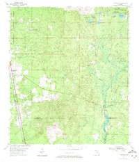
1954 Map of Woodville
USGS Topo · Published 1972About this map
The Apalachicola National Forest dominates the western landscape of this mid-century survey, where the boundary between Leon and Wakulla counties runs through the small settlements of Woodville and Vereen. The area is characterized by a complex network of wetlands and karst features, including the St Marks River and the hydrologically significant Natural Bridge Spring and Natural Bridge Sink. To the northeast, a dense cluster of lakes such as Big Lake and Lake Maltie sit near the small community of Rose.
Find a feature on this map
28 named features on this map. Tap any name to fly to it.
Don’t see what you’re looking for? This feature index may not catch every label — zoom into the map to look around manually.
Map Details
Editions of this 1954 Woodville Map
2 editions found
Other maps of this area

1940 · Tallahassee
USGS Topo · 1:62,500

1940 · Arran
USGS Topo · 1:62,500

1942 · Tallahassee
USGS Topo · 1:62,500

1943 · Arran
USGS Topo · 1:62,500

1943 · Tallahassee
USGS Topo · 1:62,500

1954 · Lloyd
USGS Topo · 1:24,000

1954 · Lafayette
USGS Topo · 1:24,000

1954 · Cody
USGS Topo · 1:24,000

1954 · Woodville
USGS Topo · 1:24,000

1954 · St. Marks NE
USGS Topo · 1:24,000