Old Maps of Manatee County, Florida
Explore 174 old maps of Manatee County, spanning from 1921 to today. These high-resolution historic maps reveal how streets, neighborhoods, landmarks, and natural features evolved over time — perfect for genealogy, metal detecting, research, and local history exploration.
What you can do with these maps:
- See how Manatee County changed over time: Compare historical maps to modern-day views to trace roads, homesites, rail lines & more.
- View detailed metadata: Each map includes creators, publishers, year, scale, and archive source.
- Overlay maps with satellite & LiDAR: Visualize the past alongside modern tools to explore terrain & human change.
- Trusted historical sources: Maps sourced from the USGS, Library of Congress, and other archives.
- Access maps your way: View online, download high-res files, or order prints for personal or research use.
Start exploring old maps of Manatee County to uncover forgotten places, hidden landmarks, and the deep history beneath your feet.
Manatee County, FL maps
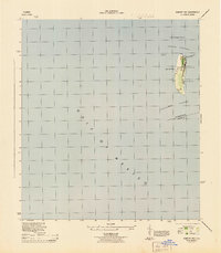
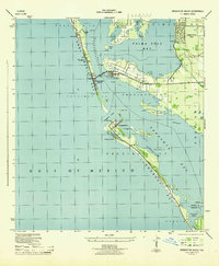
(174)- 1921 Map of Fort De Soto
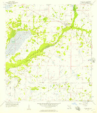
 1921 Fort De Soto1921 Print · USGSThe Florida coast at the start of the twenties reveals a landscape of isolated military outposts and emerging rail towns along the Gulf. Genealogists and historians can trace early families in Bradentown, locate the U.S. Quarantine Station, and follow the Seaboard Air Line tracks.2 unique versions available
 - 1942 Map of Cockroach Bay
 1942 Cockroach Bay1942 Print · USGSThe eastern shores of Tampa Bay are captured here in the early 1940s, highlighting the undeveloped coastal wetlands and islands of the region. Researchers can trace early infrastructure and landmarks such as the Big Cockroach Mound, the Atlantic Coast Line rail corridor, and the small community at Piney Point.
 - 1944 Map of Egmont Key
 1944 Egmont Key1944 Print · USGSEgmont Key served as a critical coastal defense and navigational hub during the mid-forties. Historians can trace specific World War II era military and maritime sites, including the Rifle Range, the Egmont Key Lt Ho, and the Casemate.2 unique versions available
 - 1944 Map of Anna Maria
 1944 Anna Maria1944 Print · USGSCoastal Manatee County is captured during the mid-forties, showing the early layout of Anna Maria and the mainland groves of Palma Sola. Trace the old shoreline landmarks from the Municipal Pier to the ancient Portavant Mound and the isolated Passage Key.2 unique versions available
 - 1944 Map of Ruskin
 1944 Ruskin1944 Print · USGSThe Florida coast south of Tampa during the mid-forties reveals a complex network of bayous and early road development. Genealogists and historians can trace the foundations of Ruskin and Sun City or locate the Ruskin Cem along the Little Manatee River.
 - 1944 Map of Rye
 1944 Rye1944 Print · USGSInland Manatee County was a landscape of citrus, timber, and wetlands during the mid-1940s. Genealogists and local historians can trace forgotten transit routes like the Rye Grade and locate old community hubs such as Manhattan and the Gulf Coast Mission.2 unique versions available
 - 1944 Map of Lower Myakka Lake
 1944 Lower Myakka Lake1944 Print · USGSSarasota County's interior is captured here in the mid-1940s, highlighting the wild wetlands and early state parkland. Genealogists and historians can locate vanished outposts like Shiney Town and Harris Camp or trace the early path of the Atlantic Coast Line.2 unique versions available
 - 1944 Map of Wimauma
 1944 Wimauma1944 Print · USGSMid-century Hillsborough County comes into focus as a landscape of citrus groves and pine flatwoods defined by the Seaboard Air Line. Trace the early development of Wimauma and its local landmarks like Moody Pond and the Wimauma Airport.
 - 1944 Map of Verna
 1944 Verna1944 Print · USGSThe Florida interior along the Manatee and Sarasota county line is captured here in the mid-1940s. Genealogists and researchers can trace the early layout of Verna and Waterbury, or locate local landmarks like Bethany Church and the long Old RR Grade.2 unique versions available
 - 1944 Map of Lorraine
 1944 Lorraine1944 Print · USGSManatee County was a patchwork of wetlands and early settlements during the mid-forties, revealing the landscape before modern suburban expansion. You can trace the historic Old RR Grade, locate the Braden River Cem, and follow the original paths of Rye Grade and Arcadia Road.2 unique versions available
 - 1944 Map of Ellenton
 1944 Ellenton1944 Print · USGSThe Manatee River coastline and Tampa Bay wetlands appear here during the mid-1940s, showing the early footprints of coastal Florida towns. Trace historical rail lines and settlements like Ellenton and Rubonia, or find the clay deposits at Fullers Earth.2 unique versions available
 - 1944 Map of Parish
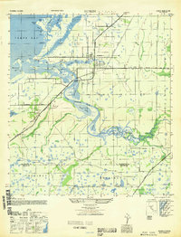
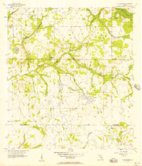
 1944 Parish1944 Print · USGSManatee County was a landscape of railroads and river bends during the mid-1940s, centered on the growing community of Parish. Researchers can trace old precincts, rural churches like New Bethel Church, and historic river landmarks including Fort Hamer.2 unique versions available
 - 1944 Map of Bradenton Beach
 1944 Bradenton Beach1944 Print · USGSThe Florida Gulf Coast appears here during the mid-forties, showing the early settlement of the barrier islands and wartime infrastructure. Genealogists and coastal historians can trace the footprints of Bradenton Beach, Longbeach, and the Army Firing Range.2 unique versions available
 - 1944 Map of Miakka
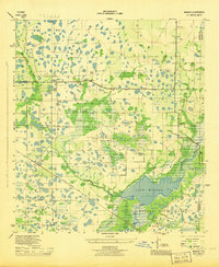 1944 Miakka1944 Print · USGSSarasota and Manatee counties were characterized by vast wetlands and isolated ranching outposts during the mid-1940s. Genealogists and local historians can trace family-named landmarks like Hi Hat Ranch, the village of Miakka, and the original Atlantic Coast Line rail corridor.3 unique versions available
 - 1945 Map of Cockroach Bay
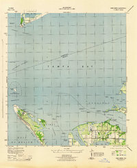
 1945 Cockroach Bay1945 Print · USGSCoastal Hillsborough and Manatee counties are captured here in the mid-1940s as an intricate system of keys, passes, and rail lines. You can trace early transit routes like the Atlantic Coast Line and locate the Ferry Ldg at Piney Point.
 - 1947 Map of Cockroach Bay
 1947 Cockroach Bay1947 Print · USGSThe eastern shore of Tampa Bay appears in the late 1940s as a labyrinth of mangrove keys and tidal passes. Genealogists and local historians can trace the early infrastructure of Piney Point, the Atlantic Coast Line railroad, and the landmark Big Cockroach Mound.
 - 1947 Map of Ruskin
 1947 Ruskin1947 Print · USGSCoastal Hillsborough and Manatee counties come into focus during the mid-forties, showing the developing settlements along the eastern bay. Genealogists and historians can trace old homesteads and landmarks near Ruskin, the Sun City Sch, and the winding Little Manatee River.
 - 1947 Map of Wimauma
 1947 Wimauma1947 Print · USGSCoastal Hillsborough County is captured here just after the war as agriculture and early aviation shaped the region. Genealogists can trace family footprints near Wimauma and Willow, or follow the historical paths of the Tamiami Trail and the Seaboard Air Line.
 - 1947 Map of Bradenton
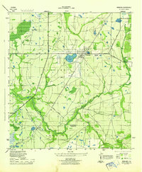
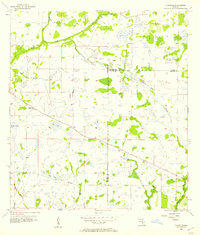
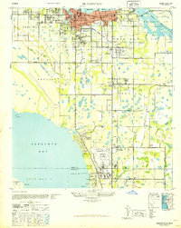 1947 Bradenton1947 Print · USGSCoastal Florida is shown in transition during the late 1940s, from the city streets of Bradenton to the large military installation at the Sarasota US Army Air Base. Researchers can trace the early layout of Whitfield Estates, locate the Manasota Cem, or find the original Prospect School site.
 - 1956 Map of Myakka City, 1957 Print
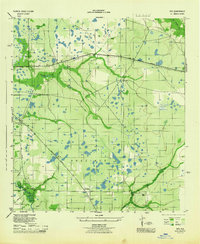
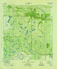
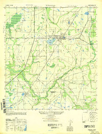
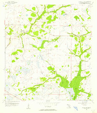
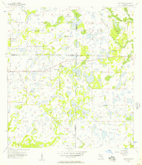
 1956 Myakka City1957 Print · USGSEastern Manatee County is shown here in the mid-fifties as a rural landscape of sprawling ranches and river wetlands. Researchers can trace the original footprints of Myakka City and Parmalee, or find family sites near Sardis Cem and the Myakka River.3 unique versions available
 - 1956 Map of Edgeville, 1957 Print
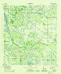
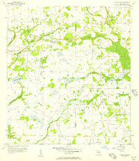
 1956 Edgeville1957 Print · USGSManatee County in the mid-fifties remains a landscape of remote pine flats and cypress sloughs. Genealogists and historians can trace early inland settlements like Edgeville and Sandy or follow the winding courses of Wildcat Slough and Owen Creek.3 unique versions available
 - 1956 Map of Myakka City NW, 1957 Print
 1956 Myakka City NW1957 Print · USGSInland Manatee County was a landscape of ranching and river headwaters during the mid-fifties. Genealogists and historians can trace the early layout of Kibler Ranch, locate a small local Cem, and explore the hydrology of Coker Prairie.3 unique versions available
 - 1956 Map of Ft Lonesome, 1957 Print
 1956 Ft Lonesome1957 Print · USGSHillsborough and Manatee counties meet in this mid-fifties landscape of prairie branches and rural outposts. Genealogists and historians can trace the sites of Ft Lonesome, Fellowship Ch, and Hurrah Ch alongside the winding Little Manatee River.4 unique versions available
 - 1956 Map of Murdock NE, 1957 Print
 1956 Murdock NE1957 Print · USGSThe Florida interior near the meeting of DeSoto, Sarasota, and Manatee counties is shown here in the mid-1950s. Genealogists and historians can trace the Old Railroad Grade and find local landmarks like Pine Level Ch and Bud Slough.4 unique versions available
 - 1956 Map of Myakka Head, 1957 Print
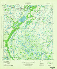
 1956 Myakka Head1957 Print · USGSThe Florida interior along the Manatee and Hardee County line is captured here in the mid-1950s, showing a landscape of scattered hammocks and winding sloughs. Genealogists and local historians can locate the New Zion Ch and the settlement at Myakka Head among the headwaters of the Myakka River.4 unique versions available
Showing maps 1-25 of 174
Top cities of Manatee County
- Bradenton historical maps
- Palmetto historical maps
- Myakka City historical maps
- Holmes Beach historical maps
- Anna Maria island historical maps
Frequently asked questions
- What are the different types of historical maps available for Manatee County?
- What is the oldest map of Manatee County?
- Where can I purchase historical maps of Manatee County for my home or office?
- Where can I download high-res historical maps of Manatee County?
- Are there historical topographic maps available for Manatee County?
- Is there historical aerial imagery available for Manatee County?
- Where are historical maps of Manatee County sourced from?