
1944 Map of Anna Maria
USGS Topo · Published 1944About this map
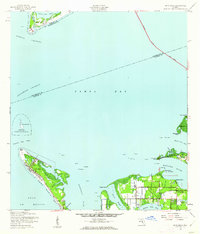
The northern end of Anna Maria island stands at the mouth of Tampa Bay in this 1944 survey, showing a landscape defined by navigation and coastal life. Near the northern tip at Bean Pt, the Municipal Pier extends into the Gulf of Mexico, serving the small settlement within Precinct 14. To the north, the isolated Passage Key is identified as the Passage Key National Wildlife Refuge, while Mullet Key at the top of the sheet features a Landing Strip and Flagstaff.
Find a feature on this map
61 named features on this map. Tap any name to fly to it.
Don’t see what you’re looking for? This feature index may not catch every label — zoom into the map to look around manually.
Map Details
Editions of this 1944 Anna Maria Map
2 editions found
Other maps of this area

1921 · Fort De Soto
USGS Topo · 1:62,500

1942 · Cockroach Bay
USGS Topo · 1:31,680

1943 · Pass-A-Grille
USGS Topo · 1:31,680

1944 · Egmont Key
USGS Topo · 1:31,680

1944 · Ellenton
USGS Topo · 1:31,680

1944 · Bradenton Beach
USGS Topo · 1:31,680

1945 · Cockroach Bay
USGS Topo · 1:31,680
1947 · Cockroach Bay
USGS Topo · 1:25,000

1947 · Bradenton
USGS Topo · 1:24,000
1949 · Pass-A-Grille
USGS Topo · 1:25,000