
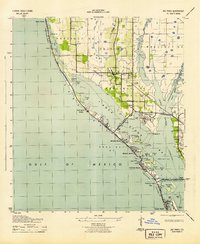
1943 Map of Pass-A-Grille
USGS Topo · Published 1943About this map
Pass-A-Grille Beach and the neighboring barrier island communities of St Petersburg Beach, Lido Beach, and Don Cesar Beach define the western shoreline of this 1943 survey. The era's transportation network is anchored by the Corey Causeway in the north and the Piney Point Ferry route extending from Point Pinellas across the bay.
Find a feature on this map
83 named features on this map. Tap any name to fly to it.
Don’t see what you’re looking for? This feature index may not catch every label — zoom into the map to look around manually.
Map Details
Editions of this 1943 Pass-A-Grille Map
This is the sole edition of this map. No revisions or reprints were ever made.
Other maps of this area

1921 · Sand Key
USGS Topo · 1:62,500

1921 · Fort De Soto
USGS Topo · 1:62,500

1921 · St Petersburg
USGS Topo · 1:62,500

1942 · Cockroach Bay
USGS Topo · 1:31,680

1943 · St Petersburg
USGS Topo · 1:31,680
1943 · Bay Pines
USGS Topo · 1:31,680

1943 · Port Tampa
USGS Topo · 1:31,680
1944 · Egmont Key
USGS Topo · 1:31,680
1944 · Anna Maria
USGS Topo · 1:31,680

1944 · Ellenton
USGS Topo · 1:31,680
Featured Places
- Saint Petersburg, FL
- Gulfport, Saint Petersburg
- Saint Pete Beach, FL
- South Pasadena, FL
- Tierra Verde, FL