
1942 Map of Cockroach Bay
USGS Topo · Published 1942About this map
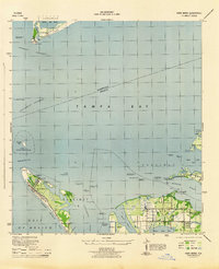
The complex shoreline of the Cockroach Bay ecosystem defines this 1940s coastal survey, revealing a landscape of intricate tidal passes and islands before mid-century development. Evidence of early habitation is centered on the Big Cockroach Mound, a significant landmark set amidst a maze of features like Hallelujah Keys and Snake Key. Along the mainland, the Atlantic Coast Line railroad and Bayshore Road provide the primary infrastructure for the sparsely settled region, which is divided between Precinct 80 and Precinct 15. Maritime and aviation navigation of the era is represented by the Cut C Rear Range Lt and an Airway Bn, while the small settlement at Piney Point marks a focal point for local activity near the Hillsborough and Manatee County line.
Find a feature on this map
42 named features on this map. Tap any name to fly to it.
Don’t see what you’re looking for? This feature index may not catch every label — zoom into the map to look around manually.
Map Details
Editions of this 1942 Cockroach Bay Map
This is the sole edition of this map. No revisions or reprints were ever made.
Other maps of this area

1921 · Tampa
USGS Topo · 1:62,500

1921 · Fort De Soto
USGS Topo · 1:62,500

1921 · St Petersburg
USGS Topo · 1:62,500

1943 · St Petersburg
USGS Topo · 1:31,680

1943 · Pass-A-Grille
USGS Topo · 1:31,680

1943 · Port Tampa
USGS Topo · 1:31,680
1944 · Anna Maria
USGS Topo · 1:31,680

1944 · Ruskin
USGS Topo · 1:31,680

1944 · Ellenton
USGS Topo · 1:31,680

1944 · Parish
USGS Topo · 1:31,680