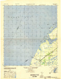
1947 Map of Cockroach Bay
USGS Topo · Published 1947About this map
Big Cockroach Mound stands as a prominent landmark on the northern edge of Cockroach Bay, anchoring a complex coastal landscape of keys, passes, and tidal inlets. This 1940s survey reveals a shoreline defined by intricate waterways such as Little Cockroach Bay and Mags Hole, punctuated by named features like the Hallelujah Keys and Snake Key.
Find a feature on this map
53 named features on this map. Tap any name to fly to it.
Don’t see what you’re looking for? This feature index may not catch every label — zoom into the map to look around manually.
Map Details
Editions of this 1947 Cockroach Bay Map
This is the sole edition of this map. No revisions or reprints were ever made.
Other maps of this area

1921 · Tampa
USGS Topo · 1:62,500

1921 · Fort De Soto
USGS Topo · 1:62,500

1921 · St Petersburg
USGS Topo · 1:62,500

1942 · Cockroach Bay
USGS Topo · 1:31,680

1943 · St Petersburg
USGS Topo · 1:31,680

1943 · Pass-A-Grille
USGS Topo · 1:31,680

1943 · Port Tampa
USGS Topo · 1:31,680

1944 · Anna Maria
USGS Topo · 1:31,680

1944 · Ruskin
USGS Topo · 1:31,680

1944 · Ellenton
USGS Topo · 1:31,680