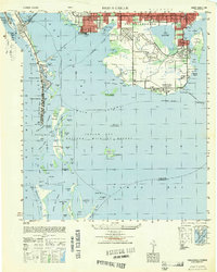
1949 Map of Pass-A-Grille
USGS Topo · Published 1949About this map
Pass-A-Grille and the barrier islands of the Florida Gulf Coast are captured here just as post-war development began to accelerate across southern Pinellas County. The map details the early footprints of coastal communities like Don Cesar Beach, Bella Vista Beach, and St Petersburg Beach, showing a landscape still dominated by open waterways and mangrove keys. Notable landmarks include the Army Camp and the Lakewood School, providing specific points of interest for local historians and genealogists researching mid-century residents.
Find a feature on this map
62 named features on this map. Tap any name to fly to it.
Don’t see what you’re looking for? This feature index may not catch every label — zoom into the map to look around manually.
Map Details
Editions of this 1949 Pass-A-Grille Map
This is the sole edition of this map. No revisions or reprints were ever made.
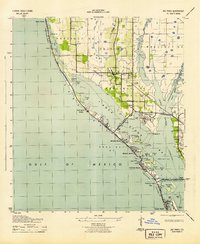
Other maps of this area

1921 · Sand Key
USGS Topo · 1:62,500

1921 · Fort De Soto
USGS Topo · 1:62,500

1921 · St Petersburg
USGS Topo · 1:62,500

1942 · Cockroach Bay
USGS Topo · 1:31,680

1943 · St Petersburg
USGS Topo · 1:31,680

1943 · Pass-A-Grille
USGS Topo · 1:31,680
1943 · Bay Pines
USGS Topo · 1:31,680

1943 · Port Tampa
USGS Topo · 1:31,680
1944 · Egmont Key
USGS Topo · 1:31,680
1944 · Anna Maria
USGS Topo · 1:31,680
Featured Places
- Saint Petersburg, FL
- Gulfport, Saint Petersburg
- Saint Pete Beach, FL
- South Pasadena, FL
- Tierra Verde, FL