
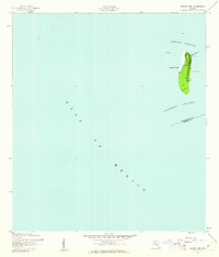
1944 Map of Egmont Key
USGS Topo · Published 1944About this map
Egmont Key stands as a strategic sentinel at the mouth of Tampa Bay, mapped here during the height of the second World War. The island's landscape is dominated by navigational and defensive infrastructure, ranging from the prominent Egmont Key Lt Ho to the Fort Dade Flagstaff. The presence of a Rifle Range and a Casemate reflects the ongoing military utility of the site, while the Weather Bureau Mast and Pilot Lookout highlight its role in maritime safety. Surrounded by the Egmont Channel and the Southwest Channel, this survey captures the keys' configuration before modern coastal changes, detailing technical landmarks like the Fog Bell, Radio Masts, and the Egmont Channel Range Front Light. The map also clearly delineates the maritime border between Hillsborough Co and Manatee Co.
Find a feature on this map
18 named features on this map. Tap any name to fly to it.
Don’t see what you’re looking for? This feature index may not catch every label — zoom into the map to look around manually.
Map Details
Editions of this 1944 Egmont Key Map
2 editions found
Other maps of this area

1921 · Fort De Soto
USGS Topo · 1:62,500

1943 · Pass-A-Grille
USGS Topo · 1:31,680

1944 · Anna Maria
USGS Topo · 1:31,680

1944 · Bradenton Beach
USGS Topo · 1:31,680
1949 · Pass-A-Grille
USGS Topo · 1:25,000
1956 · Pass-A-Grille Beach
USGS Topo · 1:24,000

1956 · Tampa
USGS Topo · 1:250,000

1959 · Tampa
USGS Topo · 1:250,000

1960 · Tampa
USGS Topo · 1:250,000
1964 · Egmont Key
USGS Topo · 1:24,000