1940s Maps of Willow, Florida
Explore 2 historic maps of Willow from the 1940s. These maps offer a rare glimpse into what life looked like during the 1940s — showing old roads, neighborhoods, homes, and landmarks that have changed or disappeared over time.
Whether you're researching your family's past, planning a metal detecting trip, or studying how Willow's landscape evolved across the 1940s, these high-resolution maps are a powerful tool for exploring the history of this region.
- Focus on a specific era: All maps on this page are from the 1940s, giving you a focused view of this time period.
- See what’s changed: Compare century-old streets, trails, and buildings to today's modern landscape using overlays and satellite layers.
- Research with precision: Use these maps for genealogy, historical research, land use analysis, or educational projects.
- View, download, or print: Maps are fully viewable online in high resolution, and can be downloaded or printed for your own records.
Start exploring Willow's history through authentic maps from the 1940s. This is your window into the past.
Willow, FL maps
(2)- 1944 Map of Wimauma
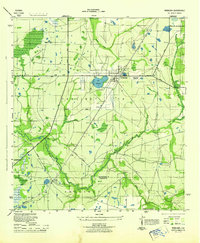 1944 Wimauma1944 Print · USGSMid-century Hillsborough County comes into focus as a landscape of citrus groves and pine flatwoods defined by the Seaboard Air Line. Trace the early development of Wimauma and its local landmarks like Moody Pond and the Wimauma Airport.
 - 1947 Map of Wimauma
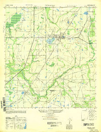 1947 Wimauma1947 Print · USGSCoastal Hillsborough County is captured here just after the war as agriculture and early aviation shaped the region. Genealogists can trace family footprints near Wimauma and Willow, or follow the historical paths of the Tamiami Trail and the Seaboard Air Line.
End of results
Showing maps 1-2 of 2
Top cities near Willow
Frequently asked questions
- What are the different types of historical maps available for Willow?
- What is the oldest map of Willow?
- Where can I purchase historical maps of Willow for my home or office?
- Where can I download high-res historical maps of Willow?
- Are there historical topographic maps available for Willow?
- Is there historical aerial imagery available for Willow?
- Where are historical maps of Willow sourced from?