1900s (20th Century) Maps of Danks Corner, Florida
Explore 6 historic maps of Danks Corner from the 1900s (20th Century). These maps offer a rare glimpse into what life looked like during the 1900s — showing old roads, neighborhoods, homes, and landmarks that have changed or disappeared over time.
Whether you're researching your family's past, planning a metal detecting trip, or studying how Danks Corner's landscape evolved across the 1900s, these high-resolution maps are a powerful tool for exploring the history of this region.
- Focus on a specific era: All maps on this page are from the 1900s, giving you a focused view of this time period.
- See what’s changed: Compare century-old streets, trails, and buildings to today's modern landscape using overlays and satellite layers.
- Research with precision: Use these maps for genealogy, historical research, land use analysis, or educational projects.
- View, download, or print: Maps are fully viewable online in high resolution, and can be downloaded or printed for your own records.
Start exploring Danks Corner's history through authentic maps from the 1900s. This is your window into the past.
Danks Corner, FL maps
(6)- 1954 Map of Gainesville, 1965 Print
 1954 Gainesville1965 Print · USGSMid-century North Central Florida comes into focus as a landscape of timber, rails, and river towns along the Gulf. Trace family roots in established centers like Gainesville or follow the path of the Suwannee River to the coastal docks of Cedar Key.3 unique versions available
 - 1958 Map of Gainesville
 1958 Gainesville1958 Print · USGSNorth Central Florida’s rail and river networks are frozen in time just before the interstate era. Genealogists and historians can trace the paths of the Atlantic Coast Line through Gainesville or locate coastal settlements like Steinhatchee and Cedar Key.
 - 1959 Map of Gainesville
 1959 Gainesville1959 Print · USGSNorth Florida in the mid-fifties is seen here from the Gulf coast to the inland lakes, showing the rail-and-river network before modern highways dominated. Researchers can trace the paths of the Seaboard Air Line through towns like Chiefland and Micanopy, or explore the coastal inlets of Waccasassa Bay.
 - 1967 Map of Belleview, 1969 Print
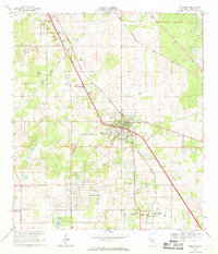 1967 Belleview1969 Print · USGSMarion County in the late sixties reveals a landscape shaped by the SEABOARD COAST LINE and the ambitious path of the PROPOSED CROSS FLORIDA BARGE CANAL. Researchers can trace the development of Belleview and locate rural landmarks like New Jerusalem Ch and Mt Pisgah Cem.2 unique versions available
 - 1978 Map of Ocala, 1980 Print
 1978 Ocala1980 Print · USGSFlorida's interior heartland and Gulf coast are seen here in the late seventies, showing the transition from freshwater springs to coastal hammocks. Genealogists and historians can trace the Seaboard Coast Line Railroad through Chiefland, Bronson, and Dunnellon.2 unique versions available
 - 1991 Map of Belleview
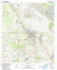 1991 Belleview1991 Print · USGSMarion County is seen during a period of steady residential expansion in the early nineties, centered on the historic crossroads at Belleview. Family researchers and local historians can trace legacy sites like Burrell Cem, Mt Pisgah Ch, and the Monroe Landing Strip.
End of results
Showing maps 1-6 of 6
Top cities near Danks Corner
- The Villages historical maps
- Ocala historical maps
- Lady Lake historical maps
- Wildwood historical maps
- Inverness historical maps
- Belleview historical maps
See more
Frequently asked questions
- What are the different types of historical maps available for Danks Corner?
- What is the oldest map of Danks Corner?
- Where can I purchase historical maps of Danks Corner for my home or office?
- Where can I download high-res historical maps of Danks Corner?
- Are there historical topographic maps available for Danks Corner?
- Is there historical aerial imagery available for Danks Corner?
- Where are historical maps of Danks Corner sourced from?