Old Maps of Martin County, Florida for Academic Research
Study the evolution of Martin County with 151 high-resolution historic maps. Whether you're teaching, researching, or modeling changes in land use, these maps provide essential visual documentation of urban, environmental, and geographic change.
- Analyze long-term change: Track patterns in development, transportation, and natural features.
- Ideal for environmental or urban studies: Support academic projects with primary historical map data.
- Use in the classroom or lab: Educators and researchers rely on these maps to bring historical context to life.
These maps are a powerful tool for teaching, research, and visualizing how Martin County has changed over the decades.
Martin County, FL maps
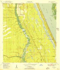
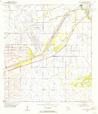
(151)- 1948 Map of Palm City, 1956 Print
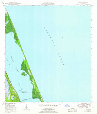
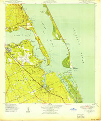
 1948 Palm City1956 Print · USGSThe St. Lucie River waterfront comes alive in this post-war survey, showing the rail and river networks of the Florida coast. Researchers can trace the development of Stuart and Palm City alongside landmarks like the Roosevelt Bridge and Union Ch.5 unique versions available
 - 1948 Map of Ankona, 1956 Print
 1948 Ankona1956 Print · USGSThe St. Lucie riverfront and coastal lagoons appear here in the late 1940s, just as the regional drainage and transport networks were maturing. Researchers can trace early infrastructure through the Florida East Coast rail line and communities like White City and Ankona.4 unique versions available
 - 1948 Map of Rood, 1958 Print
 1948 Rood1958 Print · USGSCoastal Florida's interior wetlands meet early development at the mid-century mark in this 1948 survey. Genealogists and historians can trace the local community around Rood, including the Jupiter School and landmarks like the Indian Mound and Trappers Zoo.5 unique versions available
 - 1948 Map of St. Lucie Inlet, 1958 Print
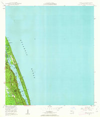
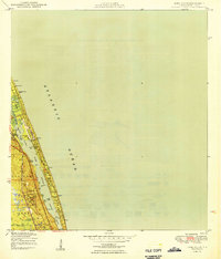
 1948 St. Lucie Inlet1958 Print · USGSCoastal Martin County comes alive in this post-war survey of the riverfronts and barrier islands near the St Lucie Inlet. Researchers can trace the rail corridor of the Florida East Coast, early neighborhoods like Rio and Salerno, and the sprawling grounds of Witham Field.4 unique versions available
 - 1948 Map of Gomez, 1958 Print
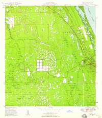 1948 Gomez1958 Print · USGSThe Florida Treasure Coast comes into focus in the years after the war, showing the distinct early footprints of Gomez and Hobe Sound. Trace the coastal development along the Florida East Coast railway or find local landmarks like the Hobe Sound Ch and the expansive Jupiter State Park.5 unique versions available
 - 1948 Map of Hobe Sound, 1962 Print
 1948 Hobe Sound1962 Print · USGSThe Martin County coast is seen here in the late 1940s, balancing pristine shoreline with early private developments. Genealogists and historians can trace coastal landmarks like the US Coast Guard Station and the sprawling Jonathan Dickinson State Park.4 unique versions available
 - 1948 Map of Jupiter, 1962 Print
 1948 Jupiter1962 Print · USGSCoastal Palm Beach County comes into focus in the late 1940s, highlighting the strategic maritime and rail corridor of the Loxahatchee River. Researchers can locate historical landmarks including the Jupiter Lighthouse Reservation, the Jupiter Cem, and the local US Navy Marine Base.5 unique versions available
 - 1948 Map of Eden, 1965 Print
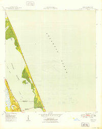
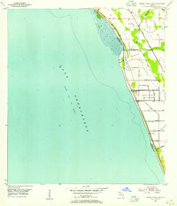
 1948 Eden1965 Print · USGSThe Florida coast near the St. Lucie and Martin County line appears here just after the war, defined by the narrow barrier of Hutchinson Island. You can trace the path of the Florida East Coast railway through Eden and find the early footprint of Jensen Beach.3 unique versions available
 - 1949 Map of Rood
 1949 Rood1949 Print · USGSThe Florida wetlands of Palm Beach and Martin counties are captured here just after the war, showing a landscape defined by cypress creeks and early water management. Researchers can locate the settlement of Rood, the Trappers Zoo, and the Jupiter Sch.2 unique versions available
 - 1949 Map of Gomez
 1949 Gomez1949 Print · USGSCoastal Martin County comes into focus in the late 1940s, showing the early infrastructure of the Atlantic seaboard and the large historical land grants. Researchers can trace the development of Hobe Sound and Gomez alongside the Florida East Coast rail line and Peck Lake.2 unique versions available
 - 1949 Map of Hobe Sound
 1949 Hobe Sound1949 Print · USGSThe Florida coast near Hobe Sound appears here in the late 1940s, just as the postwar era began to shape the shoreline. Trace early landmarks like the US Coast Guard Station, the Gomez Grant boundaries, and Jupiter State Park.2 unique versions available
 - 1950 Map of St. Lucie Inlet
 1950 St. Lucie Inlet1950 Print · USGSMid-century coastal Florida comes alive in this survey of the St. Lucie area as it appeared just after the war. Local historians can trace the foundations of Stuart and Port Sewall, the grounds of Witham Field, and the expanse of the Hanson Grant.
 - 1950 Map of Ankona
 1950 Ankona1950 Print · USGSThe Florida coast near White City is shown here just after the war, when rail and river dominated the landscape. Genealogists and historians can trace the early layout of Ankona and Walton along the Indian River and the Florida East Coast railway.
 - 1950 Map of Palm City
 1950 Palm City1950 Print · USGSMid-century coastal Florida comes alive in this survey of the river forks and early development near the Atlantic coast. Genealogists and local historians can trace the foundations of Stuart and Palm City, locating landmarks like Union Ch and the Fern Hill Cem.
 - 1950 Map of Jupiter
 1950 Jupiter1950 Print · USGSCoastal Florida is mapped in the early postwar years as the town of Jupiter begins to expand around its famous lighthouse. Genealogists and local historians can trace landmarks like the Jupiter Cem, the US Navy Marine Base, and the old Jupiter Sch.
 - 1950 Map of Eden
 1950 Eden1950 Print · USGSThe Florida coast near the Saint Lucie and Martin County line is captured here just after the war, showing the narrow reach of Hutchinson Island. You can trace the Florida East Coast rail line as it passes through Eden and across the Jensen Beach Bridge.
 - 1953 Map of Okeechobee 4 SW, 1954 Print
 1953 Okeechobee 4 SW1954 Print · USGSThe eastern shores of Lake Okeechobee are captured here in the early fifties during a period of significant water management. Historians can trace the infrastructure of the day through the Florida East Coast railway, various Windmills, and the extensive Levee system.4 unique versions available
 - 1953 Map of Okeechobee 4 SE, 1954 Print
 1953 Okeechobee 4 SE1954 Print · USGSFlorida's interior wetlands and transit corridors are captured here in the early fifties, showing the engineering of the southern drainage system. Researchers can trace the legacy of regional transport through the Seaboard Air Line, the St Lucie Canal, and the settlement of Zana.5 unique versions available
 - 1953 Map of Okeechobee 4 NE, 1954 Print
 1953 Okeechobee 4 NE1954 Print · USGSIn the early 1950s, the Florida interior along the St. Lucie and Martin County line remained a landscape of wetlands and isolated hammocks. Researchers can trace the Florida East Coast rail line and locate old sites like Bluefield and Myer Hammock.4 unique versions available
 - 1953 Map of Okeechobee 4 NW, 1954 Print
 1953 Okeechobee 4 NW1954 Print · USGSThe northeastern shore of Lake Okeechobee is captured here in the early 1950s, showing a landscape defined by drainage projects and competing rail lines. Researchers can trace the paths of the Seaboard Air Line, find the settlement at Myrtle, and locate numerous Flowing Wells across the marsh.4 unique versions available
 - 1953 Map of Indian Town SE, 1955 Print
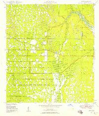
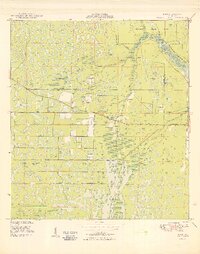
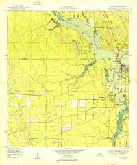
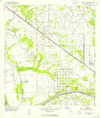
 1953 Indian Town SE1955 Print · USGSMartin County's interior was undergoing a massive transformation in the early fifties as new drainage systems reshaped the Everglades. Researchers can trace the development of the Okeechobee Waterway, the operations at the St Lucie Lock and Dam, and the small settlement of Arundel.6 unique versions available
 - 1953 Map of Indian Town NW, 1955 Print
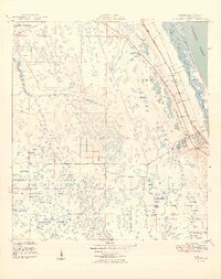
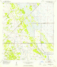
 1953 Indian Town NW1955 Print · USGSFlorida's interior wetlands meet early infrastructure in the early 1950s along the boundary of Martin and St. Lucie counties. Researchers can trace the drainage of the Allapattah Flats through an early Canal, the Green Ridge Slough, and several Levee systems.6 unique versions available
 - 1953 Map of Indian Town, 1955 Print
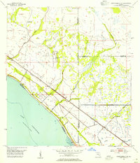
 1953 Indian Town1955 Print · USGSInland Martin County is captured in the early fifties, showing a landscape defined by massive water management projects and early transit hubs. Researchers can trace the path of the Seaboard Air Line and the St Lucie Canal through the Allapattah Flats.4 unique versions available
 - 1956 Map of West Palm Beach, 1964 Print
 1956 West Palm Beach1964 Print · USGSSouth Florida during the mid-fifties exhibits a fascinating balance between expanding coastal cities and the vast interior wetlands. Researchers can trace the development of inland settlements like Immokalee and Okeelanta or locate vanished landmarks like Chosen and Buckingham Cem.2 unique versions available
 - 1956 Map of Fort Pierce, 1965 Print
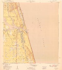
 1956 Fort Pierce1965 Print · USGSCentral and coastal Florida appear here during a period of rapid post-war growth and industrial expansion. Researchers can trace the mid-century rail-to-highway transition along the Sunshine State Parkway or locate old settlements like Ankona, Walton, and Indrio.4 unique versions available
Showing maps 1-25 of 151
Top cities of Martin County
- Stuart historical maps
- Jensen Beach historical maps
- Port Salerno historical maps
- North River Shores historical maps
- Sewall's Point historical maps
- Jupiter Island historical maps
See more
Frequently asked questions
- What are the different types of historical maps available for Martin County?
- What is the oldest map of Martin County?
- Where can I purchase historical maps of Martin County for my home or office?
- Where can I download high-res historical maps of Martin County?
- Are there historical topographic maps available for Martin County?
- Is there historical aerial imagery available for Martin County?
- Where are historical maps of Martin County sourced from?