1970s Maps of Islamorada, Florida
Explore 4 historic maps of Islamorada from the 1970s. These maps offer a rare glimpse into what life looked like during the 1970s — showing old roads, neighborhoods, homes, and landmarks that have changed or disappeared over time.
Whether you're researching your family's past, planning a metal detecting trip, or studying how Islamorada's landscape evolved across the 1970s, these high-resolution maps are a powerful tool for exploring the history of this region.
- Focus on a specific era: All maps on this page are from the 1970s, giving you a focused view of this time period.
- See what’s changed: Compare century-old streets, trails, and buildings to today's modern landscape using overlays and satellite layers.
- Research with precision: Use these maps for genealogy, historical research, land use analysis, or educational projects.
- View, download, or print: Maps are fully viewable online in high resolution, and can be downloaded or printed for your own records.
Start exploring Islamorada's history through authentic maps from the 1970s. This is your window into the past.
Islamorada, FL maps
(4)- 1971 Map of Upper Matecumbe Key, 1973 Print
 1971 Upper Matecumbe Key1973 Print · USGSThe Florida Keys are captured here in the early seventies, showing the transition from isolated outposts to a connected coastal corridor. Map collectors can trace the Intracoastal Waterway and locate sites like Islamorada and Lignumvitae Key.3 unique versions available
 - 1971 Map of Tavernier, 1973 Print
 1971 Tavernier1973 Print · USGSThe Florida Keys in the early seventies reveal a detailed look at the maritime and coastal geography around Plantation Key. Genealogists and local historians can trace the early layout of Tavernier, locating landmarks such as the Burton Memorial United Ch and the busy Tavernier Harbor.2 unique versions available
 - 1971 Map of Plantation Key, 1973 Print
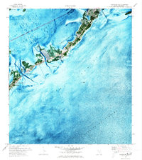 1971 Plantation Key1973 Print · USGSThe upper Florida Keys are captured in detail during the early seventies, showcasing a landscape of coral keys and narrow maritime channels. Genealogists and historians can trace the early footprints of Islamorada, the Coast Guard Sta, and Coral Shores Sch.2 unique versions available
 - 1971 Map of Lower Matecumbe Key, 1973 Print
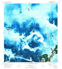
 1971 Lower Matecumbe Key1973 Print · USGSLower Matecumbe Key in the early seventies reveals a landscape of growing coastal communities and deep-water channels. Researchers can trace the development of Matecumbe Harbor and locate offshore sites like Indian Key Anchorage and Channel Two.
End of results
Showing maps 1-4 of 4
Top cities near Islamorada
Top neighborhoods of Islamorada
Frequently asked questions
- What are the different types of historical maps available for Islamorada?
- What is the oldest map of Islamorada?
- Where can I purchase historical maps of Islamorada for my home or office?
- Where can I download high-res historical maps of Islamorada?
- Are there historical topographic maps available for Islamorada?
- Is there historical aerial imagery available for Islamorada?
- Where are historical maps of Islamorada sourced from?