Old Maps of Perky, Florida for Metal Detecting
Plan your next treasure hunt with 11 historic maps of Perky. Find old homesites, ghost towns, trails, and gathering spots that may be lost to time — perfect for identifying promising metal detecting locations.
- Locate forgotten sites: Uncover places like long-lost settlements, abandoned rail lines, or gathering spots.
- Plan better hunts: Use map overlays combined with LiDAR or satellite views to narrow in on historically rich areas.
- Made for detectorists: Thousands of hobbyists use these maps to discover relics, coins, and hidden history.
Use these historic maps to boost your research and find new opportunities beneath the surface of Perky.
Perky, FL maps
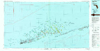
(11)- 1921 Map of Sugar Loaf Key
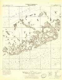 1921 Sugar Loaf Key1921 Print · USGSThe Lower Florida Keys are captured here in the early twentieth century before modern development transformed the island chain. Maritime researchers and genealogists can trace the original shorelines of Sugarloaf Key, Cudjoe Key, and family-named landmarks like Mallorys Key.2 unique versions available
 - 1943 Map of Sugarloaf Key
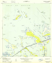 1943 Sugarloaf Key1943 Print · USGSThe Florida Keys during the early 1940s are seen here as infrastructure begins to reshape the maritime landscape. Researchers can locate the settlement at Perky, trace the highway route under construction, and find landmarks at Pirates Cove.3 unique versions available
 - 1972 Map of Sugarloaf Key, 1975 Print
 1972 Sugarloaf Key1975 Print · USGSThe Lower Florida Keys in the early seventies reveal a landscape of expanding coastal settlements and strategic military outposts. Researchers can trace the development of Sugarloaf Shores and Pirates Cove alongside the Cudjoe Key Air Force Site.
 - 1983 Map of Key West, 1984 Print
 1983 Key West1984 Print · USGSThe Lower Florida Keys are shown in detail in the early 1980s, centered on the military and civilian infrastructure of the archipelago. Trace the path of the Overseas Highway across the Sevenmile Bridge and locate historic sites like Bahia Honda State Park.2 unique versions available
 - 1989 Map of Key West, 1990 Print
 1989 Key West1990 Print · USGSThe Florida Keys at the end of the eighties reveal a complex maritime network of coral islands, military outposts, and protected wilderness. Researchers can trace the Overseas Highway across the Sevenmile Bridge and locate features like the U S Naval Air Station Key West and the National Key Deer Refuge.
 - 2012 Map of Sugarloaf Key, 2012 Print
 2012 Sugarloaf Key2012 Print · USGSCovers Perky, including Pirates Cove, Bay Point, and other nearby areas
 - 2015 Map of Sugarloaf Key, 2015 Print
 2015 Sugarloaf Key2015 Print · USGSCovers Perky, including Pirates Cove, Bay Point, and other nearby areas
 - 2018 Map of Sugarloaf Key, 2018 Print
 2018 Sugarloaf Key2018 Print · USGSCovers Perky, including Pirates Cove, Bay Point, and other nearby areas
 - 2021 Map of Sugarloaf Key, 2021 Print
 2021 Sugarloaf Key2021 Print · USGSCovers Perky, including Pirates Cove, Bay Point, and other nearby areas
 - 2024 Map of Sugarloaf Key, 2024 Print
 2024 Sugarloaf Key2024 Print · USGSCovers Perky, including Pirates Cove, Bay Point, and other nearby areas
 - 2025 Map of Sugarloaf Key, 2025 Print
 2025 Sugarloaf Key2025 Print · USGSThe Lower Florida Keys are shown in high detail at a time when modern development and coastal preserves meet. Researchers can trace the layout of island communities like Perky and Sugarloaf Shores or locate the Sugarloaf Shores Airport.
End of results
Showing maps 1-11 of 11
Top cities near Perky
Frequently asked questions
- What are the different types of historical maps available for Perky?
- What is the oldest map of Perky?
- Where can I purchase historical maps of Perky for my home or office?
- Where can I download high-res historical maps of Perky?
- Are there historical topographic maps available for Perky?
- Is there historical aerial imagery available for Perky?
- Where are historical maps of Perky sourced from?