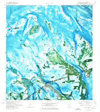
1972 Map of Sugarloaf Key
USGS Topo · Published 1975About this map
Great White Heron National Wildlife Refuge and the National Key Deer Refuge dominate this 1970s orthophotomap of the Florida Keys, where the land-and-water boundary is defined by mangroves and shallow tidal basins. The map illustrates a period of mid-century infrastructure and military presence, featuring the Cudjoe Key Air Force Site and the U.S. Naval Communications Station situated near Fivemile Creek. Residential footprints are visible at Sugarloaf Shores and Pirates Cove, supported by local facilities like the Sugarloaf Sch and the Sugarloaf Shores Airport. Small settlements such as Noston, Easton, and Marvy are marked among the various keys, including Pumpkin Key and the Barracuda Keys. The orthophoto base provides a clear view of the underwater channels, such as Bow Channel and Kemp Channel, which were vital for navigating these treacherous flats before modern dredging.
Find a feature on this map
58 named features on this map. Tap any name to fly to it.
Don’t see what you’re looking for? This feature index may not catch every label — zoom into the map to look around manually.
Map Details
Editions of this 1972 Sugarloaf Key Map
This is the sole edition of this map. No revisions or reprints were ever made.
Other maps of this area

1921 · Sugar Loaf Key
USGS Topo · 1:62,500

1943 · Saddlebunch Keys
USGS Topo · 1:24,000

1943 · Boca Chica
USGS Topo · 1:24,000

1943 · Snipe Keys
USGS Topo · 1:24,000

1943 · Sugarloaf Key
USGS Topo · 1:24,000

1968 · Saddlebunch Keys
USGS Topo · 1:24,000
1971 · Boca Chica Key
USGS Topo · 1:24,000

1972 · Loggerhead Key
USGS Topo · 1:24,000
1972 · Sawyer Key
USGS Topo · 1:24,000

1972 · Content Keys
USGS Topo · 1:24,000