
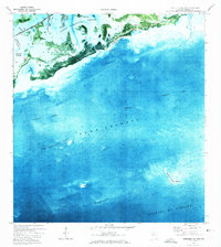
1972 Map of Loggerhead Key
USGS Topo · Published 1973About this map
Loggerhead Key and its surrounding tropical waters are documented here in the early 1970s through a combination of aerial orthophotography and planetable surveys. The map provides a detailed view of the submerged reefs and shallow flats of the lower Florida Keys, transitioning from the sheltered Newfound Harbor Keys and Big Munson Island out into the deeper Hawk Channel. A critical maritime infrastructure is visible along the northern edge, where the Intracoastal Waterway cuts through the shallows, supported by a Light for nighttime navigation. Further south, the coral structure of Looe Key stands as a prominent landmark before the seafloor drops away into the vast Straits of Florida. This survey serves as a precise record of the shoreline and reef configurations prior to later environmental shifts and modern development.
Find a feature on this map
9 named features on this map. Tap any name to fly to it.
Don’t see what you’re looking for? This feature index may not catch every label — zoom into the map to look around manually.
Map Details
Editions of this 1972 Loggerhead Key Map
2 editions found

Other maps of this area

1921 · Sugar Loaf Key
USGS Topo · 1:62,500

1943 · Saddlebunch Keys
USGS Topo · 1:24,000

1943 · Sugarloaf Key
USGS Topo · 1:24,000

1968 · Saddlebunch Keys
USGS Topo · 1:24,000

1972 · Big Pine Key
USGS Topo · 1:24,000
1972 · Saddlebunch Keys
USGS Topo · 1:24,000

1972 · Summerland Key
USGS Topo · 1:24,000

1972 · Sugarloaf Key
USGS Topo · 1:24,000

1983 · Key West
USGS Topo · 1:100,000

1989 · Key West
USGS Topo · 1:250,000