
1943 Map of Saddlebunch Keys
USGS Topo · Published 1943About this map
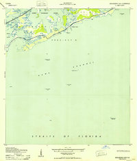
Saddlebunch Keys and Sugarloaf Key form a low-lying archipelago in this mid-century survey of Precinct 8 in Monroe County. The map captures a landscape defined by saltwater transitions, where Lower Sugarloaf Sound and Sugarloaf Cr divide the limestone and mangrove terrain. Maritime safety is paramount, evidenced by several offshore navigational markers including the American Shoal Lighthouse and Rebecca Shoal Lighthouse positioned along the Hawk Channel and the Straits of Florida. Transportation across the islands was in a state of transition during the war years, with the primary thoroughfare through the keys noted as under construction. Small coastal settlements like Sugaloa Beach and isolated landmarks such as Wells Key and Pirates Cove Bn 7 provide specific points of interest for researchers of Florida's coastal history before the postwar development boom.
Find a feature on this map
18 named features on this map. Tap any name to fly to it.
Don’t see what you’re looking for? This feature index may not catch every label — zoom into the map to look around manually.
Map Details
Editions of this 1943 Saddlebunch Keys Map
2 editions found
Other maps of this area

1921 · Sugar Loaf Key
USGS Topo · 1:62,500

1943 · Boca Chica
USGS Topo · 1:24,000

1943 · Snipe Keys
USGS Topo · 1:24,000

1943 · Sugarloaf Key
USGS Topo · 1:24,000

1968 · Saddlebunch Keys
USGS Topo · 1:24,000
1971 · Boca Chica Key
USGS Topo · 1:24,000

1972 · Loggerhead Key
USGS Topo · 1:24,000
1972 · Snipe Keys
USGS Topo · 1:24,000
1972 · Saddlebunch Keys
USGS Topo · 1:24,000

1972 · Summerland Key
USGS Topo · 1:24,000