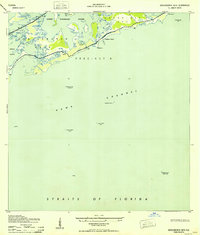
1943 Map of Saddlebunch Keys
USGS Topo · Published 1943About this map
Saddlebunch Keys and Sugarloaf Key form the heart of this coastal study, compiled from air photographs by the U.S. Coast and Geodetic Survey during the early 1940s. The landscape is dominated by the intricate mangroves and tidal waters of Lower Sugarloaf Sound and Sugarloaf Cr, showing the primitive state of these islands before significant development. A single road, marked simply as 1, traverses the archipelago, providing a vital link through Precinct 8. To the south, the deep waters of Hawk Channel and the Straits of Florida are monitored by critical maritime aids, including the Rebecca Shoal Lighthouse and the American Shoal Lighthouse. The inclusion of Sugaloa Beach and Pirates Cove Bn 7 captures the mid-century character of these islands when they were primarily defined by their natural shoreline and strategic maritime location.
Find a feature on this map
30 named features on this map. Tap any name to fly to it.
Don’t see what you’re looking for? This feature index may not catch every label — zoom into the map to look around manually.
Map Details
Editions of this 1943 Saddlebunch Keys Map
2 editions found
Other maps of this area

1921 · Sugar Loaf Key
USGS Topo · 1:62,500

1943 · Saddlebunch Keys
USGS Topo · 1:24,000

1943 · Boca Chica
USGS Topo · 1:24,000

1943 · Snipe Keys
USGS Topo · 1:24,000

1943 · Sugarloaf Key
USGS Topo · 1:24,000

1968 · Saddlebunch Keys
USGS Topo · 1:24,000
1971 · Boca Chica Key
USGS Topo · 1:24,000

1972 · Loggerhead Key
USGS Topo · 1:24,000
1972 · Snipe Keys
USGS Topo · 1:24,000
1972 · Saddlebunch Keys
USGS Topo · 1:24,000