
1972 Map of Content Keys
USGS Topo · Published 1973About this map
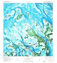
The Great White Heron National Wildlife Refuge dominates this sub-tropical seascape in Monroe County, Florida, illustrating a complex environment of shallow banks and mangrove islands. In the early 1970s, this area remained largely untouched by development, defined by the shifting shoals of Turtlecrawl Bank and Spanish Banks. Deep-water navigation is clearly delineated by the Intracoastal Waterway and the expansive Big Spanish Channel, which provide vital corridors through the otherwise precarious shallows. The map captures the scattered islands of the Content Keys and Wherry Keys, alongside larger landforms like Howe Key and Annette Key. The presence of the National Key Deer Refuge Boundary emphasizes the conservation status of this region, highlighting the importance of the mangrove habitats such as Howe Key Mangrove for local marine and avian species.
Find a feature on this map
21 named features on this map. Tap any name to fly to it.
Don’t see what you’re looking for? This feature index may not catch every label — zoom into the map to look around manually.
Map Details
Editions of this 1972 Content Keys Map
This is the sole edition of this map. No revisions or reprints were ever made.
Other maps of this area

1921 · Sugar Loaf Key
USGS Topo · 1:62,500

1943 · Sugarloaf Key
USGS Topo · 1:24,000

1972 · Big Pine Key
USGS Topo · 1:24,000

1972 · Sawyer Key
USGS Topo · 1:24,000

1972 · Horseshoe Keys
USGS Topo · 1:24,000

1972 · Summerland Key
USGS Topo · 1:24,000
1972 · Sugarloaf Key
USGS Topo · 1:24,000

1983 · Key West
USGS Topo · 1:100,000

1989 · Key West
USGS Topo · 1:250,000
2012 · Horseshoe Keys
USGS Topo · 1:24,000