1930s Maps of Okaloosa County, Florida
Explore 12 historic maps of Okaloosa County from the 1930s. These maps offer a rare glimpse into what life looked like during the 1930s — showing old roads, neighborhoods, homes, and landmarks that have changed or disappeared over time.
Whether you're researching your family's past, planning a metal detecting trip, or studying how Okaloosa County's landscape evolved across the 1930s, these high-resolution maps are a powerful tool for exploring the history of this region.
- Focus on a specific era: All maps on this page are from the 1930s, giving you a focused view of this time period.
- See what’s changed: Compare century-old streets, trails, and buildings to today's modern landscape using overlays and satellite layers.
- Research with precision: Use these maps for genealogy, historical research, land use analysis, or educational projects.
- View, download, or print: Maps are fully viewable online in high resolution, and can be downloaded or printed for your own records.
Start exploring Okaloosa County's history through authentic maps from the 1930s. This is your window into the past.
Okaloosa County, FL maps
(12)- 1934 Map of Holt
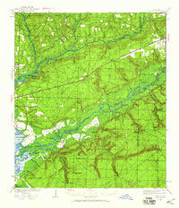
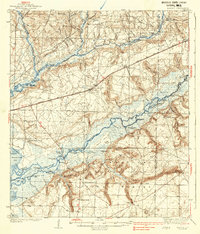
 1934 Holt1934 Print · USGSOkaloosa County at the height of the Great Depression was defined by the massive Choctawhatchee National Forest and the early timber industry. Researchers can trace the path of the Louisville and Nashville Railroad and locate vanished sites like Keyser Mill, TURPENTINE CAMP, and Antioch Ch.
 - 1934 Map of Harold
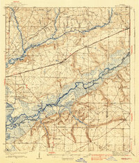
 1934 Harold1934 Print · USGSSanta Rosa County and the Florida Panhandle are shown here in the 1930s, defined by the winding paths of the Blackwater and Yellow Rivers. Researchers can locate family landmarks like the Old Whitmier Place, Kellys Mill, and several river access points including Faulks Ferry Landing.3 unique versions available
 - 1934 Map of Niceville
 1934 Niceville1934 Print · USGSThe Florida Panhandle in the mid-thirties reveals a landscape of tidal bayous and managed pine forests. Researchers can trace early infrastructure like the Bolton Turpentine Still, State Convict Camp No 12, and the path of the Old Spanish Trail.
 - 1935 Map of Villa Tasso
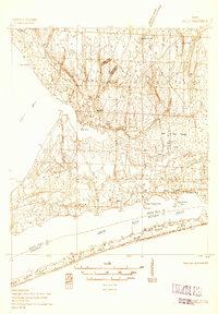
 1935 Villa Tasso1935 Print · USGSThe Florida Panhandle's coast appears here in the mid-1930s, showing a landscape of federal forests and burgeoning recreation. You can trace early sites like Postls Resort, the State 4H Club Camp, and the extensive Moreno Point Military Reservation.
 - 1936 Map of Niceville
 1936 Niceville1936 Print · USGSThe Okaloosa and Walton County line area is documented here in the mid-1930s, showing the transition from northern rail towns to coastal settlements. You can trace early family landmarks and infrastructure like Early Cem, Spencer Flats, and the Ramer Lookout Tower.4 unique versions available
 - 1936 Map of Holley
 1936 Holley1936 Print · USGSThe Florida Panhandle coast near Santa Rosa County appears here during the mid-1930s, showing a quiet landscape of timber and wetlands. Genealogists and historians can trace early settlements at Holley and Navarre or locate landmarks like the Indian Head Fire Tower and Holley Ch.3 unique versions available
 - 1937 Map of Holt
 1937 Holt1937 Print · USGSNorth Florida’s pine woods and river landings are captured in the mid-1930s, just as modern forestry and rail networks were maturing. Genealogists can trace old routes like the Nashville Trail or locate early industrial sites such as Bowser Mill and the Tar Plant.4 unique versions available
 - 1937 Map of Harold, 1942 Print
 1937 Harold1942 Print · USGSSanta Rosa County's river-and-rail landscape is captured here in the mid-1930s, showing a world of timber landings and rural parishes. Trace family history through Pleasant Home Ch, find the Old Whitmier Place, or locate Faulks Ferry Landing along the Yellow River.
 - 1938 Map of Mary Esther
 1938 Mary Esther1938 Print · USGSThe Florida Panhandle coastline appears in the mid-1930s as a landscape of federal forests and quiet waterfront settlements. You can trace the early footprints of Fort Walton and Mary Esther, or locate forestry landmarks like the Pinchot Lookout Tower.4 unique versions available
 - 1938 Map of Villa Tasso
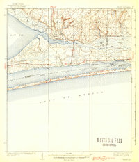
 1938 Villa Tasso1938 Print · USGSChoctawhatchee Bay and the Emerald Coast appear here in the mid-1930s, showing a landscape defined by military land and national forest. Trace early development in Valparaiso or follow the Gulf Coast Highway past coastal gems like Stewart Lake and Topsail Hill.4 unique versions available
 - 1938 Map of Holley
 1938 Holley1938 Print · USGSThe Florida Panhandle's coastline and interior forests appear here in the mid-thirties, before modern development transformed the shore. Researchers can trace early settlements at Holley and Navarre or locate landmarks like the East Bay Ch and East Bay Ranger Station.3 unique versions available
 - 1938 Map of Harold
 1938 Harold1938 Print · USGSThe Florida panhandle comes alive in the late 1930s, showing a timber-and-rail landscape shaped by the Blackwater River. Genealogists and historians can trace family roots at Old Whitmier Place, Flowers Field Cemetery, and several rural churches like Welcome Ch.4 unique versions available
End of results
Showing maps 1-12 of 12
Top cities of Okaloosa County
- Crestview historical maps
- Fort Walton Beach historical maps
- Destin historical maps
- Niceville historical maps
- Valparaiso historical maps
- Mary Esther historical maps
See more
Frequently asked questions
- What are the different types of historical maps available for Okaloosa County?
- What is the oldest map of Okaloosa County?
- Where can I purchase historical maps of Okaloosa County for my home or office?
- Where can I download high-res historical maps of Okaloosa County?
- Are there historical topographic maps available for Okaloosa County?
- Is there historical aerial imagery available for Okaloosa County?
- Where are historical maps of Okaloosa County sourced from?