1990s Maps of Orlando, Florida
Explore 2 historic maps of Orlando from the 1990s. These maps offer a rare glimpse into what life looked like during the 1990s — showing old roads, neighborhoods, homes, and landmarks that have changed or disappeared over time.
Whether you're researching your family's past, planning a metal detecting trip, or studying how Orlando's landscape evolved across the 1990s, these high-resolution maps are a powerful tool for exploring the history of this region.
- Focus on a specific era: All maps on this page are from the 1990s, giving you a focused view of this time period.
- See what’s changed: Compare century-old streets, trails, and buildings to today's modern landscape using overlays and satellite layers.
- Research with precision: Use these maps for genealogy, historical research, land use analysis, or educational projects.
- View, download, or print: Maps are fully viewable online in high resolution, and can be downloaded or printed for your own records.
Start exploring Orlando's history through authentic maps from the 1990s. This is your window into the past.
Orlando, FL maps
(2)- 1994 Map of Orlando East, 2000 Print
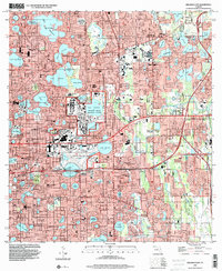 1994 Orlando East2000 Print · USGSOrlando and Winter Park at the end of the century are depicted here as a thriving network of lakefront neighborhoods and major institutional campuses. Researchers can trace the layout of the Orlando Naval Training Center, find local schools like Lakemont Sch, or locate the historic Greenwood Cemetery.
 - 1995 Map of Orlando West, 2000 Print
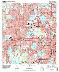 1995 Orlando West2000 Print · USGSWestern Orlando and the historic town of Eatonville are shown during a period of significant growth in the mid-nineties. Genealogists and local historians can trace neighborhood development near Washington Park Cem, St Andrews Ch, and the landmark Tangerine Bowl.
End of results
Showing maps 1-2 of 2
Top cities near Orlando
- Alafaya historical maps
- Kissimmee historical maps
- Kissimmee historical maps
- Kissimmee historical maps
- Kissimmee historical maps
- Ocoee historical maps
See more
Top neighborhoods of Orlando
- MetroWest historical maps
- Vista East historical maps
- East Park historical maps
- Lake Nona historical maps
- Vista Lakes historical maps
- Parramore historical maps
See more
Frequently asked questions
- What are the different types of historical maps available for Orlando?
- What is the oldest map of Orlando?
- Where can I purchase historical maps of Orlando for my home or office?
- Where can I download high-res historical maps of Orlando?
- Are there historical topographic maps available for Orlando?
- Is there historical aerial imagery available for Orlando?
- Where are historical maps of Orlando sourced from?