1970s Maps of Palm Beach County, Florida
Explore 34 historic maps of Palm Beach County from the 1970s. These maps offer a rare glimpse into what life looked like during the 1970s — showing old roads, neighborhoods, homes, and landmarks that have changed or disappeared over time.
Whether you're researching your family's past, planning a metal detecting trip, or studying how Palm Beach County's landscape evolved across the 1970s, these high-resolution maps are a powerful tool for exploring the history of this region.
- Focus on a specific era: All maps on this page are from the 1970s, giving you a focused view of this time period.
- See what’s changed: Compare century-old streets, trails, and buildings to today's modern landscape using overlays and satellite layers.
- Research with precision: Use these maps for genealogy, historical research, land use analysis, or educational projects.
- View, download, or print: Maps are fully viewable online in high resolution, and can be downloaded or printed for your own records.
Start exploring Palm Beach County's history through authentic maps from the 1970s. This is your window into the past.
Palm Beach County, FL maps
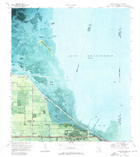
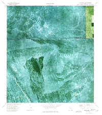
(34)- 1970 Map of Lake Harbor, 1971 Print
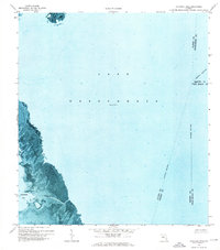
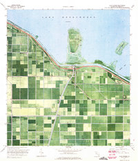 1970 Lake Harbor1971 Print · USGSThe southern rim of Lake Okeechobee comes into focus in the early 1970s as a hub of massive agricultural reclamation and rail transport. Trace the old rail lines of the Seaboard Coast Line and explore lakeside settlements like Bean City and Lake Harbor.2 unique versions available
 - 1970 Map of Belle Glade, 1972 Print
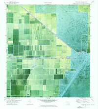
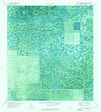
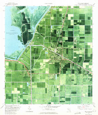 1970 Belle Glade1972 Print · USGSPalm Beach County’s agricultural heartland is documented here in the early seventies, showing the intricate canal networks and the growth of Belle Glade. Genealogists and historians can trace local institutions like Rosenwald Sch and the development of South Bay near the lake's edge.3 unique versions available
 - 1970 Map of Lake Harbor SE, 1976 Print
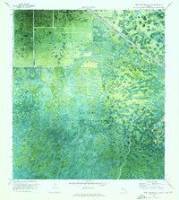
 1970 Lake Harbor SE1976 Print · USGSPalm Beach County’s agricultural interior is shown here in the 1970s as a highly engineered landscape of industrial-scale farming. Researchers can trace the water management network along the Bolles Canal and locate the Seaboard Coast Line railroad and local Landing Strip.
 - 1970 Map of West Palm Beach 2 SW, 1976 Print
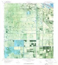
 1970 West Palm Beach 2 SW1976 Print · USGSPalm Beach County in the early seventies reveals the sharp divide between the preserved wetlands of the Corbett State Wildlife Management Area and expanding agricultural drainage systems. Researchers can trace the path of the West Palm Beach Canal and locate landmarks like the Landing Strip and Big Mound.2 unique versions available
 - 1970 Map of Lake Harbor SW, 1976 Print
 1970 Lake Harbor SW1976 Print · USGSThe Hendry and Palm Beach borderlands in the 1970s reveal a landscape of intensive water management and wetland conversion. Researchers can trace the drainage network of the Bolles Canal past landmarks like Tonys Mound and Cowbone Hammock.
 - 1970 Map of Clewiston South, 1976 Print
 1970 Clewiston South1976 Print · USGSAs the Everglades' sugar industry matured in the early 1970s, this survey captured the engineered landscape south of Clewiston. Trace the rail-and-canal network through Sugar Junction and identify family-named sites like Hooker Point and Keela.2 unique versions available
 - 1970 Map of Loxahatchee SE, 1976 Print
 1970 Loxahatchee SE1976 Print · USGSThe northern Everglades take center stage in the 1970s, showing the intersection of managed wetlands and water engineering. Trace the artificial boundary of the L-40 Canal where industrial Pumps manage the flow into Conservation Area No 1.3 unique versions available
 - 1970 Map of Okeelanta, 1976 Print
 1970 Okeelanta1976 Print · USGSThe northern Everglades in the early seventies shows an intensely managed agricultural landscape centered on Okeelanta. Researchers can trace industrial growth through the Seaboard Coast Line and water management along Bolles Canal.2 unique versions available
 - 1970 Map of Loxahatchee NW, 1976 Print
 1970 Loxahatchee NW1976 Print · USGSPalm Beach County's engineered landscape is captured here in the early 1970s, showing the transition from wetland conservation to industrial agriculture. Map users can trace the paths of the West Palm Beach Canal and Ocean Canal through Twentymile Bend.2 unique versions available
 - 1970 Map of Loxahatchee SW, 1976 Print
 1970 Loxahatchee SW1976 Print · USGSPalm Beach County’s western frontier is captured here during the early 1970s, illustrating the engineering of the Everglades. Researchers can trace the water control network along the Hillsboro Canal and see the interface of the Loxahatchee National Wildlife Refuge and industrial agriculture.
 - 1970 Map of West Palm Beach 2 NE, 1976 Print
 1970 West Palm Beach 2 NE1976 Print · USGSFlorida's inland wetlands near the Palm Beach and Martin County line were largely undeveloped in the early seventies. Track the path of the Seaboard Coast Line past the Palm Beach Raceway and the rural outpost of Apix.3 unique versions available
 - 1970 Map of Pahokee, 1976 Print
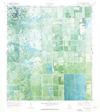
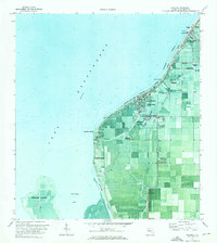 1970 Pahokee1976 Print · USGSPalm Beach County's agricultural heartland is documented here at the start of the seventies, where the massive dike system meets the lake. Genealogists and local historians can locate Pahokee landmarks like Lakeside Ch, the East Lake Sch, and the Palm Beach Co Glades Airport.
 - 1970 Map of Shawano, 1976 Print
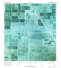 1970 Shawano1976 Print · USGSPalm Beach County's agricultural interior comes into focus during the early seventies as a massive network of industrial drainage and field grids. Researchers can trace the layout of Shawano and the vital water paths of the Hillsboro Canal and Bolles Canal.2 unique versions available
 - 1970 Map of Bryant, 1976 Print
 1970 Bryant1976 Print · USGSPalm Beach County agriculture is captured in the early 1970s, showcasing a highly engineered landscape of industrial-scale farming and water control. Researchers can trace the layout of Bryant, the path of the West Palm Beach Canal, and local infrastructure like the Landing Strip.
 - 1970 Map of Sixmile Bend, 1976 Print
 1970 Sixmile Bend1976 Print · USGSPalm Beach County’s agricultural heartland is captured here in the early seventies, showing the vast grid of the Everglades drainage system. Researchers can trace irrigation infrastructure and local landmarks like Chamblee, Sixmile Bend, and the Private Railroad.
 - 1970 Map of West Palm Beach 2 NW, 1976 Print
 1970 West Palm Beach 2 NW1976 Print · USGSThe northern reaches of the Everglades transition into industrial and transit corridors in the 1970s. Researchers can trace the path of the Seaboard Coast Line and locate landmarks like Big Mound and the Water Tank within the Corbett State Wildlife Management Area.3 unique versions available
 - 1971 Map of Clewiston North, 1976 Print
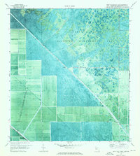
 1971 Clewiston North1976 Print · USGSThe southern shores of Lake Okeechobee are shown here in the early seventies as the town of Clewiston expanded along the dike. Local researchers can trace the developed grid of Clewiston, the location of the Ridgelawn Cem, and early marsh access via an Airboat Trail.3 unique versions available
 - 1971 Map of Cochrans Pass, 1976 Print
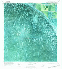
 1971 Cochrans Pass1976 Print · USGSLake Okeechobee and its western marshlands are captured in high detail during the early 1970s. Trace the seasonal water patterns and historic navigation routes like Cochrans Pass, the Airboat Tr, and Moonshine Bay.
 - 1971 Map of West Palm Beach 2 SE, 1976 Print
 1971 West Palm Beach 2 SE1976 Print · USGSThe northern Everglades transition into managed wilderness in the early 1970s, where water and land engineering meet. Researchers can trace the development of the L-8 Canal and identify remote landmarks like the South Florida Youth Conservation Camp and Hungryland.3 unique versions available
 - 1971 Map of Loxahatchee, 1976 Print
 1971 Loxahatchee1976 Print · USGSPalm Beach County’s marshy interior was a land of intensive water management in the early seventies. Genealogists and historians can trace the canals and infrastructure that shaped the area, from the Zoological Garden to the West Palm Beach Canal.
 - 1971 Map of Port Mayaca, 1976 Print
 1971 Port Mayaca1976 Print · USGSThe eastern shores of Lake Okeechobee meet the vast agricultural interior of South Florida in the early 1970s. Researchers can trace the intersection of water and rail transport at Port Mayaca, locating landmarks like the Macedonia Ch and the St Lucie Canal.
 - 1971 Map of West Palm Beach 2 SW, 1984 Print
 1971 West Palm Beach 2 SW1984 Print · USGSPalm Beach County's interior wetlands and drainage networks are meticulously documented in this early 1970s survey. Researchers can trace the engineering of the West Palm Beach Canal alongside landmarks like Big Mound and the Landing Strip.
 - 1973 Map of Fort Lauderdale 2 NE, 1976 Print
 1973 Fort Lauderdale 2 NE1976 Print · USGSPalm Beach County’s Everglades wilderness is captured here in the early seventies through detailed aerial photography. Researchers can trace the water management markers of Conservation Area No 1 and find remote spots like Bobs Camp and Bobs Lake.2 unique versions available
 - 1973 Map of Fort Lauderdale 2 SW, 1976 Print
 1973 Fort Lauderdale 2 SW1976 Print · USGSThe Florida Everglades are captured in the early 1970s, revealing a landscape of managed wetlands and water conservation. Researchers can trace the path of the North New River Canal or follow specialized routes like the Airboat Trail and Weasel Trail.2 unique versions available
 - 1974 Map of Everglades 1 SW, 1976 Print
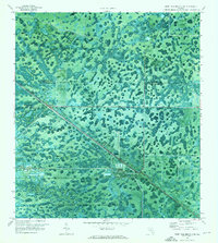
 1974 Everglades 1 SW1976 Print · USGSThe Florida Everglades in the mid-1970s reveal a landscape defined by water management and wetland navigation. Researchers can trace the path of the Miami Canal and numerous Airboat Trails crossing through Conservation Area No 3A.2 unique versions available
Showing maps 1-25 of 34
Top cities of Palm Beach County
- West Palm Beach historical maps
- Boca Raton historical maps
- Boynton Beach historical maps
- Delray Beach historical maps
- Wellington historical maps
- Palm Beach Gardens historical maps
See more
Frequently asked questions
- What are the different types of historical maps available for Palm Beach County?
- What is the oldest map of Palm Beach County?
- Where can I purchase historical maps of Palm Beach County for my home or office?
- Where can I download high-res historical maps of Palm Beach County?
- Are there historical topographic maps available for Palm Beach County?
- Is there historical aerial imagery available for Palm Beach County?
- Where are historical maps of Palm Beach County sourced from?