1960s Maps of Palm Beach County, Florida
Explore 5 historic maps of Palm Beach County from the 1960s. These maps offer a rare glimpse into what life looked like during the 1960s — showing old roads, neighborhoods, homes, and landmarks that have changed or disappeared over time.
Whether you're researching your family's past, planning a metal detecting trip, or studying how Palm Beach County's landscape evolved across the 1960s, these high-resolution maps are a powerful tool for exploring the history of this region.
- Focus on a specific era: All maps on this page are from the 1960s, giving you a focused view of this time period.
- See what’s changed: Compare century-old streets, trails, and buildings to today's modern landscape using overlays and satellite layers.
- Research with precision: Use these maps for genealogy, historical research, land use analysis, or educational projects.
- View, download, or print: Maps are fully viewable online in high resolution, and can be downloaded or printed for your own records.
Start exploring Palm Beach County's history through authentic maps from the 1960s. This is your window into the past.
Palm Beach County, FL maps
(5)- 1962 Map of Boca Raton, 1963 Print
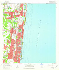 1962 Boca Raton1963 Print · USGSThe Florida coast near Boca Raton was undergoing a suburban boom in the early sixties, as seen through its new canal subdivisions and highway expansions. Trace the development of Lighthouse Point and find local landmarks like Boca Raton Cem and University Park.5 unique versions available
 - 1962 Map of Delray Beach, 1964 Print
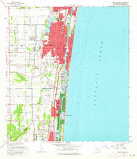 1962 Delray Beach1964 Print · USGSPalm Beach County's Gold Coast is shown during its mid-century transition from a rail-dependent agricultural corridor to a premier residential shoreline. Researchers can trace the layout of early neighborhoods and schools like Yamato, Spady Sch, and Tropic Isle.5 unique versions available
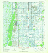
 - 1962 Map of West Dixie Bend, 1964 Print
 1962 West Dixie Bend1964 Print · USGSBroward County experiences a period of rapid development in the early sixties as the suburbs press against the Everglades. Researchers can trace early street grids and neighborhood boundaries for Margate, Sanders Park, and Carver Village alongside the Sunshine State Parkway.3 unique versions available
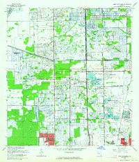
 - 1962 Map of University Park, 1966 Print
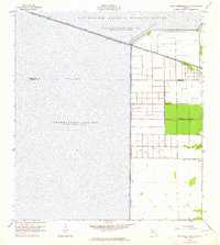
 1962 University Park1966 Print · USGSPalm Beach County in the early sixties reveals a landscape of massive water conservation efforts meeting a gridded agricultural frontier. Genealogists and historians can trace early residential clusters like University-Park and schools such as St Andrews Preparatory Sch.3 unique versions available
 - 1963 Map of Fort Lauderdale 2 SE, 1964 Print
 1963 Fort Lauderdale 2 SE1964 Print · USGSThe northern Everglades and the Broward-Palm Beach border are caught in transition during the early 1960s as water management reshapes the land. Trace the massive engineering of Levee No 39 and the Hillsboro Canal alongside the Loxahatchee National Wildlife Refuge.5 unique versions available
End of results
Showing maps 1-5 of 5
Top cities of Palm Beach County
- West Palm Beach historical maps
- Boca Raton historical maps
- Boynton Beach historical maps
- Delray Beach historical maps
- Wellington historical maps
- Palm Beach Gardens historical maps
See more
Frequently asked questions
- What are the different types of historical maps available for Palm Beach County?
- What is the oldest map of Palm Beach County?
- Where can I purchase historical maps of Palm Beach County for my home or office?
- Where can I download high-res historical maps of Palm Beach County?
- Are there historical topographic maps available for Palm Beach County?
- Is there historical aerial imagery available for Palm Beach County?
- Where are historical maps of Palm Beach County sourced from?