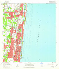
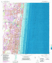
1962 Map of Boca Raton
USGS Topo · Published 1963About this map
Boca Raton and the surrounding coastline show rapid mid-century expansion along the Intracoastal Waterway in this early 1960s survey. The landscape is a mix of established neighborhoods like Floresta and Paradise Palms alongside emerging developments such as Royal Oak Hills and Floresta Estates. Transportation networks define the area, with the Florida East Coast and Seaboard Air Line railroads running parallel to the coast, while the Sunshine State Pkwy skirts the western edge. Cultural landmarks of the era include University Park, the Royal Palm Yacht Club, and a Drive-in Theater near Shorewood. The map provides excellent detail for genealogists and local historians, showing specific religious and educational sites like St Pauls Ch and the Florida Junior Academy. From the Boca Raton Inlet south to Lighthouse Point, the intricate canal systems of The Cove and Barwal illustrate the decade's transformative waterfront engineering.
Find a feature on this map
77 named features on this map. Tap any name to fly to it.
Don’t see what you’re looking for? This feature index may not catch every label — zoom into the map to look around manually.
Map Details
Editions of this 1962 Boca Raton Map
5 editions found
Other maps of this area

1945 · Fort Lauderdale North
USGS Topo · 1:24,000

1946 · West Dixie Bend
USGS Topo · 1:24,000

1946 · Boca Raton
USGS Topo · 1:24,000

1947 · Delmar Farms
USGS Topo · 1:24,000

1949 · Fort Lauderdale North
USGS Topo · 1:24,000

1949 · West Dixie Bend
USGS Topo · 1:24,000

1949 · Pompano Beach
USGS Topo · 1:24,000

1949 · Delmar Farms
USGS Topo · 1:24,000

1950 · Boca Raton
USGS Topo · 1:24,000

1950 · Delray Beach
USGS Topo · 1:24,000