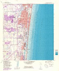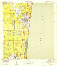
1950 Map of Delray Beach
USGS Topo · Published 1950About this map
Delray Beach and Boca Raton serve as the primary hubs in this coastal survey, which documents the shoreline just after the mid-century. The landscape is defined by the parallel infrastructure of the Florida East Coast and Seaboard Air Line railroads, illustrating the transport-driven growth of Palm Beach County. Coastal development is concentrated between the Intracoastal Waterway and the Atlantic Ocean, while the interior reveals a mix of agricultural and industrial utility, from the Borrow Pit south of Delray Beach to the Rifle Range near the municipal border. The presence of the Boca Raton Municipal Airport at the southern edge highlights the area's transition from wartime activity to civil aviation. Inland, the Military Trail and Germantown Road cut through a low-lying terrain of marshes and small water bodies like Lake Ida, marking the early limits of westward expansion before the post-war boom fully transformed the Everglades' edge.
Find a feature on this map
21 named features on this map. Tap any name to fly to it.
Don’t see what you’re looking for? This feature index may not catch every label — zoom into the map to look around manually.
Map Details
Editions of this 1950 Delray Beach Map
2 editions found
Historical Maps of Boca Raton Through Time
7 maps found