
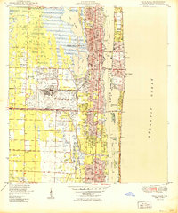
1950 Map of Greenacres City
USGS Topo · Published 1950About this map
Greenacres City sits at the northeastern edge of this mid-century landscape, where early development began pushing into the eastern Everglades. The map captures an era of extensive land reclamation and agricultural expansion, dominated by a grid of canals and a recurring Levee system designed to manage water flow across the low-lying terrain. Large-scale drainage projects are evidenced by the expansive tracts of (Palm Beach Farms) and (Delmar Farms), which illustrate the transition from swamp to organized farmland.
Find a feature on this map
17 named features on this map. Tap any name to fly to it.
Don’t see what you’re looking for? This feature index may not catch every label — zoom into the map to look around manually.
Map Details
Editions of this 1950 Greenacres City Map
This is the sole edition of this map. No revisions or reprints were ever made.
Other maps of this area

1945 · Greenacres City
USGS Topo · 1:24,000

1945 · Lake Worth
USGS Topo · 1:24,000

1946 · Palm Beach Farms
USGS Topo · 1:24,000

1946 · Palm Beach
USGS Topo · 1:24,000

1947 · Delmar Farms
USGS Topo · 1:24,000

1949 · Lake Worth
USGS Topo · 1:24,000

1949 · Palm Beach Farms
USGS Topo · 1:24,000

1949 · Delmar Farms
USGS Topo · 1:24,000

1950 · Delray Beach
USGS Topo · 1:24,000
1950 · Palm Beach
USGS Topo · 1:24,000