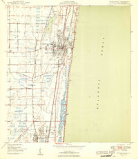
1950 Map of Delray Beach
USGS Topo · Published 1950About this map
Delray Beach and the surrounding Gold Coast are captured in the mid-1940s, revealing a landscape of coastal development and agricultural hinterlands. The parallel paths of the Florida East Coast and Seaboard Air Line railroads dictated the expansion of settlements like Boynton, Gulf Stream, and Boca Raton. A notable feature of this era is the Japanese settler colony of Yamato, appearing here before the post-war building boom significantly altered the region's character. Inland from the Intracoastal Waterway, the grid of Military Trail and Germantown Road marks the boundary between the town centers and the marshy expanses near Lake Ida. Infrastructure for the growing population and wartime presence is evident at the Boca Raton Municipal Airport and the nearby Rifle Range, while local landmarks like Christ Ch and various golf courses reflect the area's social fabric.
Find a feature on this map
25 named features on this map. Tap any name to fly to it.
Don’t see what you’re looking for? This feature index may not catch every label — zoom into the map to look around manually.
Map Details
Editions of this 1950 Delray Beach Map
2 editions found
Other maps of this area

1945 · Greenacres City
USGS Topo · 1:24,000

1945 · Lake Worth
USGS Topo · 1:24,000

1946 · West Dixie Bend
USGS Topo · 1:24,000

1946 · Boca Raton
USGS Topo · 1:24,000

1947 · Delmar Farms
USGS Topo · 1:24,000

1949 · Lake Worth
USGS Topo · 1:24,000

1949 · West Dixie Bend
USGS Topo · 1:24,000

1949 · Delmar Farms
USGS Topo · 1:24,000

1950 · Boca Raton
USGS Topo · 1:24,000

1950 · Delray Beach
USGS Topo · 1:24,000