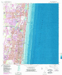
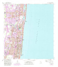
1962 Map of Boca Raton
USGS Topo · Published 1987About this map
Boca Raton and Deerfield Beach show significant suburban expansion along the Florida coast in this early 1960s survey, updated with mid-1980s bathymetric and photorevised data. The Intracoastal Waterway serves as a central artery for the region, separating the mainland from the barrier beach developments of Hillsboro Beach and Ocean Vue. Two major rail lines, the Seaboard Coast Line and Florida East Coast, parallel the shoreline, while the Sunshine State Parkway and Federal Highway provide the backbone for automotive transit. Community life is anchored by local institutions like Mitchell Sch and St Gregory Ch. The map also highlights the area's aviation infrastructure with the Boca Raton Public Airport and Pompano Beach Airpark, alongside leisure landmarks such as the Royal Palm Yacht Club.
Find a feature on this map
72 named features on this map. Tap any name to fly to it.
Don’t see what you’re looking for? This feature index may not catch every label — zoom into the map to look around manually.
Map Details
Editions of this 1962 Boca Raton Map
5 editions found
Other maps of this area

1945 · Fort Lauderdale North
USGS Topo · 1:24,000

1946 · West Dixie Bend
USGS Topo · 1:24,000

1946 · Boca Raton
USGS Topo · 1:24,000

1947 · Delmar Farms
USGS Topo · 1:24,000

1949 · Fort Lauderdale North
USGS Topo · 1:24,000

1949 · West Dixie Bend
USGS Topo · 1:24,000

1949 · Pompano Beach
USGS Topo · 1:24,000

1949 · Delmar Farms
USGS Topo · 1:24,000

1950 · Boca Raton
USGS Topo · 1:24,000

1950 · Delray Beach
USGS Topo · 1:24,000