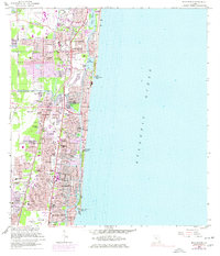
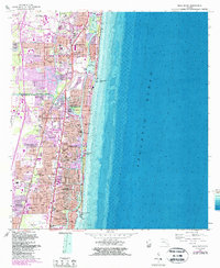
1962 Map of Boca Raton
USGS Topo · Published 1977About this map
The Intracoastal Waterway and the Hillsboro River define the coastal geometry of southeast Florida during a period of rapid suburban expansion. Following the 1960s, a purple tint on this sheet highlights the growth of residential developments like Floresta Estates, Paradise Palms, and Shorewood. This era of development is etched into the landscape through the emergence of neighborhood clusters around golf courses and the Royal Palm Country Club, while maintaining older corridors like the Florida East Coast and Seaboard Coast Line railroads.
Find a feature on this map
72 named features on this map. Tap any name to fly to it.
Don’t see what you’re looking for? This feature index may not catch every label — zoom into the map to look around manually.
Map Details
Editions of this 1962 Boca Raton Map
5 editions found
Other maps of this area

1945 · Fort Lauderdale North
USGS Topo · 1:24,000

1946 · West Dixie Bend
USGS Topo · 1:24,000

1946 · Boca Raton
USGS Topo · 1:24,000

1947 · Delmar Farms
USGS Topo · 1:24,000

1949 · Fort Lauderdale North
USGS Topo · 1:24,000

1949 · West Dixie Bend
USGS Topo · 1:24,000

1949 · Pompano Beach
USGS Topo · 1:24,000

1949 · Delmar Farms
USGS Topo · 1:24,000

1950 · Boca Raton
USGS Topo · 1:24,000

1950 · Delray Beach
USGS Topo · 1:24,000