1950s Maps of Pinellas County, Florida
Explore 12 historic maps of Pinellas County from the 1950s. These maps offer a rare glimpse into what life looked like during the 1950s — showing old roads, neighborhoods, homes, and landmarks that have changed or disappeared over time.
Whether you're researching your family's past, planning a metal detecting trip, or studying how Pinellas County's landscape evolved across the 1950s, these high-resolution maps are a powerful tool for exploring the history of this region.
- Focus on a specific era: All maps on this page are from the 1950s, giving you a focused view of this time period.
- See what’s changed: Compare century-old streets, trails, and buildings to today's modern landscape using overlays and satellite layers.
- Research with precision: Use these maps for genealogy, historical research, land use analysis, or educational projects.
- View, download, or print: Maps are fully viewable online in high resolution, and can be downloaded or printed for your own records.
Start exploring Pinellas County's history through authentic maps from the 1950s. This is your window into the past.
Pinellas County, FL maps
(12)- 1952 Map of Safety Harbor
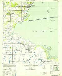 1952 Safety Harbor1952 Print · USGSCoastal Pinellas County comes into focus during the early postwar years, showing a landscape of small settlements and military aviation. Trace the historic route of the Davis Causeway and its Toll House, or locate the runways of the Pinellas Army Airfield.
 - 1955 Map of Plant City, 1966 Print
 1955 Plant City1966 Print · USGSMid-century Central Florida comes to life in this survey of the Nature Coast and the inland citrus and rail belt. Genealogists and historians can trace the paths of the Atlantic Coast Line, locate the Anclote Keys Lighthouse, or find old communities like Masaryktown and Lacoochee.6 unique versions available
 - 1956 Map of Safety Harbor, 1957 Print
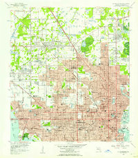
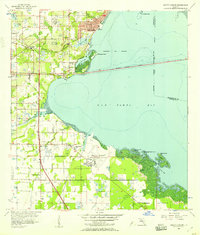 1956 Safety Harbor1957 Print · USGSPinellas County's eastern shore is captured in the mid-fifties, showing the growth of coastal towns before the era of intensive development. Genealogists and historians can locate early family landmarks like McMullen Cem, the Drive-in Theater, and Safety Harbor.5 unique versions available
 - 1956 Map of Gandy Bridge, 1957 Print
 1956 Gandy Bridge1957 Print · USGSThe Tampa waterfront and Interbay Peninsula are seen here during a period of post-war suburban expansion. Genealogists and local historians can trace mid-century growth through schools like Plant High Sch and industrial sites at Rattlesnake.6 unique versions available
 - 1956 Map of Cockroach Bay, 1957 Print
 1956 Cockroach Bay1957 Print · USGSThe Gulf Coast shoreline of the mid-fifties comes alive through this detailed survey of the coastal wetlands and islands. Researchers can trace early railroad history along the Atlantic Coast Line or find landmarks like the Big Cockroach Mound and Piney Point.5 unique versions available
 - 1956 Map of St. Petersburg, 1957 Print
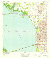
 1956 St. Petersburg1957 Print · USGSMid-century St. Petersburg shows a bustling coastal city during its post-war growth phase between the Gulf and the bay. Researchers can trace historic schools and aviation landmarks like Farragut Academy, St Jude Sch, and Whitted Airport.5 unique versions available
 - 1956 Map of Pass-A-Grille Beach, 1957 Print
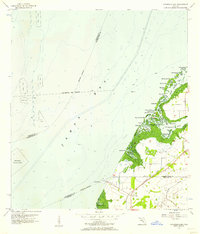
 1956 Pass-A-Grille Beach1957 Print · USGSPinellas County's southern coast in the mid-fifties shows the burgeoning beach communities of Pass-a-Grille Beach and St Petersburg Beach. Local historians can trace early neighborhood plats near Lake Maggiore or locate the Don Ce-Sar Place landmark.4 unique versions available
 - 1956 Map of Port Tampa, 1957 Print
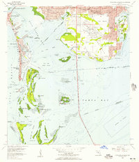
 1956 Port Tampa1957 Print · USGSThe Tampa Bay shoreline was a hub of military and industrial activity in the mid-fifties, with the sprawling Mac Dill Air Force Base facing the growing suburbs of St Petersburg. Researchers can trace the era's infrastructure from the Gandy Bridge to the rail-fed Port Tampa Dock.6 unique versions available
 - 1956 Map of Tampa, 1964 Print
 1956 Tampa1964 Print · USGSThe Florida Gulf Coast thrived in the mid-fifties, from the bustling docks of Tampa to the quiet shores of Sanibel. Genealogists and historians can trace old rail lines like the Atlantic Coast Line or find early layouts of Port Charlotte and Bokeelia.2 unique versions available
 - 1958 Map of Plant City
 1958 Plant City1958 Print · USGSFlorida's Gulf Coast and inland ridge country are captured here in the mid-fifties, showing the region before modern sprawl. Genealogists and historians can trace rail-era towns like Richland and Trilby or locate coastal landmarks such as the Anclote Keys Lighthouse.
 - 1959 Map of Plant City
 1959 Plant City1959 Print · USGSThe West Florida coast and inland timberlands are captured here in the late fifties, from the bend of the Gulf to the rail hubs of the interior. Trace the paths of the Atlantic Coast Line through Inverness and find landmarks like the Anclote Keys Lighthouse.
 - 1959 Map of Tampa
 1959 Tampa1959 Print · USGSThe Florida Gulf Coast appears in this late fifties survey during a period of steady coastal growth and established rail commerce. Researchers can trace historic neighborhoods and transit lines from Tampa to St Petersburg, or locate landmarks like Mac Dill AFB and Boca Grande.
End of results
Showing maps 1-12 of 12
Top cities of Pinellas County
- Saint Petersburg historical maps
- Clearwater historical maps
- Largo historical maps
- Palm Harbor historical maps
- Pinellas Park historical maps
- Dunedin historical maps
See more
Frequently asked questions
- What are the different types of historical maps available for Pinellas County?
- What is the oldest map of Pinellas County?
- Where can I purchase historical maps of Pinellas County for my home or office?
- Where can I download high-res historical maps of Pinellas County?
- Are there historical topographic maps available for Pinellas County?
- Is there historical aerial imagery available for Pinellas County?
- Where are historical maps of Pinellas County sourced from?