1970s Maps of Pinellas County, Florida
Explore 8 historic maps of Pinellas County from the 1970s. These maps offer a rare glimpse into what life looked like during the 1970s — showing old roads, neighborhoods, homes, and landmarks that have changed or disappeared over time.
Whether you're researching your family's past, planning a metal detecting trip, or studying how Pinellas County's landscape evolved across the 1970s, these high-resolution maps are a powerful tool for exploring the history of this region.
- Focus on a specific era: All maps on this page are from the 1970s, giving you a focused view of this time period.
- See what’s changed: Compare century-old streets, trails, and buildings to today's modern landscape using overlays and satellite layers.
- Research with precision: Use these maps for genealogy, historical research, land use analysis, or educational projects.
- View, download, or print: Maps are fully viewable online in high resolution, and can be downloaded or printed for your own records.
Start exploring Pinellas County's history through authentic maps from the 1970s. This is your window into the past.
Pinellas County, FL maps
(8)- 1972 Map of Tampa, 1974 Print
 1972 Tampa1974 Print · USGSThe Florida Gulf Coast appears in a period of significant growth during the early seventies, from the urban centers of the bay to the quiet southern keys. Researchers can trace the expansion of St Petersburg or locate family sites near Safety Harbor, Valrico, and Boca Ciega.
 - 1973 Map of Tarpon Springs, 1975 Print
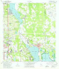
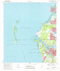 1973 Tarpon Springs1975 Print · USGSFlorida's Gulf Coast underwent rapid development in the early seventies as residential canals and suburban plats began to surround the historic sponge-fishing hub of Tarpon Springs. Researchers can trace the waterfront growth from Gulf Harbors to the Anclote River, including landmarks like the southern Lighthouse and the old Seaboard Coast Line rail corridor.4 unique versions available
 - 1974 Map of Elfers, 1975 Print
 1974 Elfers1975 Print · USGSThe West Florida coast in the mid-seventies shows a landscape in transition as suburbs replaced rural sloughs and bayous. Genealogists and historians can trace the growth of New Port Richey, locate several burial grounds like East Elfers Cem, and follow the Seaboard Coast Line through Seven Springs.2 unique versions available
 - 1974 Map of Clearwater, 1976 Print
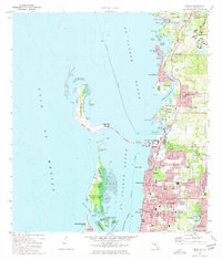
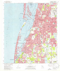 1974 Clearwater1976 Print · USGSThe Pinellas County coastline shows extensive mid-century development and dredging just before the mid-seventies. Trace local history through landmarks like the Rousseau Pioneer Cem, the Seaboard Coast Line tracks, and the Pinellas Plant.2 unique versions available
 - 1974 Map of Seminole, 1976 Print
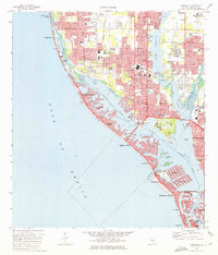 1974 Seminole1976 Print · USGSThe Pinellas County coastline was undergoing rapid residential expansion in the mid-seventies, particularly across the barrier islands and finger canals. Researchers can trace the development of Seminole and Bay Pines, locating landmarks like the VA Hospital, Bauder Sch, and the Seaboard Coast Line.2 unique versions available
 - 1974 Map of Oldsmar, 1976 Print
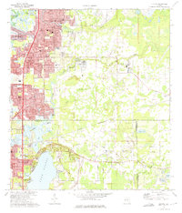
 1974 Oldsmar1976 Print · USGSCoastal Pinellas and Hillsborough counties are shown here in the mid-seventies as suburban growth began to surround the upper reaches of Old Tampa Bay. Genealogists and local historians can trace the development of Oldsmar, the grounds of Sylvan Abbey Memorial Park, and the ancient Indian Mound at Philippe Point.2 unique versions available
 - 1974 Map of Dunedin, 1977 Print
 1974 Dunedin1977 Print · USGSCoastal Pinellas County comes into focus in the mid-seventies, showing a landscape defined by barrier islands and rapid residential growth. Genealogists and local historians can trace family sites near Dunedin Cem, the Seaboard Coast Line tracks, and early churches like Berea Ch.3 unique versions available
 - 1978 Map of Tarpon Springs, 1982 Print
 1978 Tarpon Springs1982 Print · USGSCoastal Florida is shown during its late-century period of rapid growth, from the Gulf shores to the deep inland swamps. Researchers can trace the development of the Intracoastal Waterway and locate regional landmarks like the Anclote Missile Tracking Annex and Lake Tarpon.
End of results
Showing maps 1-8 of 8
Top cities of Pinellas County
- Saint Petersburg historical maps
- Clearwater historical maps
- Largo historical maps
- Palm Harbor historical maps
- Pinellas Park historical maps
- Dunedin historical maps
See more
Frequently asked questions
- What are the different types of historical maps available for Pinellas County?
- What is the oldest map of Pinellas County?
- Where can I purchase historical maps of Pinellas County for my home or office?
- Where can I download high-res historical maps of Pinellas County?
- Are there historical topographic maps available for Pinellas County?
- Is there historical aerial imagery available for Pinellas County?
- Where are historical maps of Pinellas County sourced from?