1990s Maps of Pinellas County, Florida
Explore 10 historic maps of Pinellas County from the 1990s. These maps offer a rare glimpse into what life looked like during the 1990s — showing old roads, neighborhoods, homes, and landmarks that have changed or disappeared over time.
Whether you're researching your family's past, planning a metal detecting trip, or studying how Pinellas County's landscape evolved across the 1990s, these high-resolution maps are a powerful tool for exploring the history of this region.
- Focus on a specific era: All maps on this page are from the 1990s, giving you a focused view of this time period.
- See what’s changed: Compare century-old streets, trails, and buildings to today's modern landscape using overlays and satellite layers.
- Research with precision: Use these maps for genealogy, historical research, land use analysis, or educational projects.
- View, download, or print: Maps are fully viewable online in high resolution, and can be downloaded or printed for your own records.
Start exploring Pinellas County's history through authentic maps from the 1990s. This is your window into the past.
Pinellas County, FL maps
(10)- 1994 Map of Pass-A-Grille Beach, 1999 Print
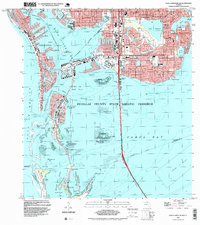 1994 Pass-A-Grille Beach1999 Print · USGSThe Pinellas coastline in the 1990s shows a dense network of suburban development intertwined with critical island preserves. Researchers can trace local neighborhoods from Gulfport to Coquina Key and locate institutional landmarks like Lakeview Sch or the Municipal Pier.
 - 1995 Map of Tarpon Springs, 1998 Print
 1995 Tarpon Springs1998 Print · USGSThe Florida Gulf Coast near the Pasco and Pinellas county line is shown here in the mid-nineties as suburban development met the salt marsh. Trace the intricate canal layouts of Gulf Harbors, the grounds of St Petersburg Jr College, and local landmarks like the Municipal Pier.
 - 1995 Map of Seminole, 1999 Print
 1995 Seminole1999 Print · USGSThe Pinellas County coastline is shown here in the mid-nineties, featuring the intricate canal systems of Treasure Island and Madeira Beach. Researchers can trace the layout of the V A Cem at Bay Pines or locate local landmarks like the Pinellas Plant and St Jerome Ch.
 - 1995 Map of Clearwater, 2000 Print
 1995 Clearwater2000 Print · USGSPinellas County's Gulf coast appears at a peak of late-century development, showing the dense suburban expansion of Clearwater and Largo. Genealogists and historians can locate neighborhood landmarks like Anona Sch, St Pauls Ch, and the St Petersburg NW Base.
 - 1995 Map of Oldsmar, 2000 Print
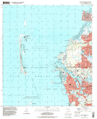
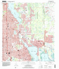 1995 Oldsmar2000 Print · USGSCoastal Pinellas and Hillsborough counties are shown during a period of rapid suburban maturation in the mid-nineties. Local historians can trace established neighborhoods like Oldsmar and Harbor Palms alongside landmarks like the Florida Downs Racetrack and the Indian Mound near Philippe Pt.
 - 1998 Map of Safety Harbor, 2001 Print
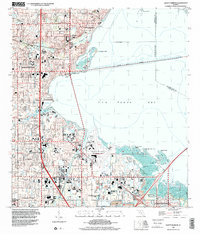 1998 Safety Harbor2001 Print · USGSThe Pinellas County coastline was heavily developed by the late nineties, featuring a network of schools and civic spaces along Old Tampa Bay. Genealogists and local historians can trace legacy sites like the McMullen Cem and Haines Road Ch alongside the Saint Petersburg-Clearwater International Airport.
 - 1998 Map of Dunedin, 2001 Print
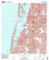
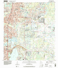
 1998 Dunedin2001 Print · USGSCoastal Pinellas County comes into focus at the end of the century, showing the established communities of Dunedin and Palm Harbor. Genealogists and local historians can trace the layouts of Ozona, find the Dunedin Cem, or locate landmarks like Wall Springs.
 - 1998 Map of Elfers, 2001 Print
 1998 Elfers2001 Print · USGSCoastal Pasco and Pinellas counties are seen here in the late twentieth century as suburban growth filled the corridors between historic river settlements. Trace local family roots at East Elfers Cem or locate community landmarks like Riverside Chapel and the Tampa Bay Executive Airport.
 - 1998 Map of Saint Petersburg, 2001 Print
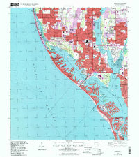
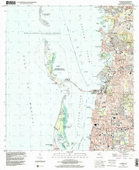
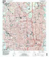 1998 Saint Petersburg2001 Print · USGSThe Florida Suncoast's urban expansion is on full display here as the suburbs of Saint Petersburg and Pinellas Park mature. Researchers can locate specific neighborhood landmarks like Farragut Academy, Albert Whitted Airport, and the Royal Palm Cemetery.
 - 1998 Map of Gandy Bridge, 2002 Print
 1998 Gandy Bridge2002 Print · USGSTampa and the Interbay Peninsula are shown in the late nineties as a fully integrated hub of aviation and coastal transit. Genealogists and local historians can trace the development of neighborhood schools like Plant High Sch or locate the American Legion Cem and Drew Park.
End of results
Showing maps 1-10 of 10
Top cities of Pinellas County
- Saint Petersburg historical maps
- Clearwater historical maps
- Largo historical maps
- Palm Harbor historical maps
- Pinellas Park historical maps
- Dunedin historical maps
See more
Frequently asked questions
- What are the different types of historical maps available for Pinellas County?
- What is the oldest map of Pinellas County?
- Where can I purchase historical maps of Pinellas County for my home or office?
- Where can I download high-res historical maps of Pinellas County?
- Are there historical topographic maps available for Pinellas County?
- Is there historical aerial imagery available for Pinellas County?
- Where are historical maps of Pinellas County sourced from?