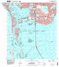
1994 Map of Pass-A-Grille Beach
USGS Topo · Published 1999About this map
The complex coastal geography of Pinellas County is meticulously detailed in this late 20th-century survey, showcasing the dense residential and recreational development of St Petersburg and Gulfport. The map captures a transition period where natural wildlife habitats such as the Pinellas National Wildlife Refuge on Indian Key exist alongside massive infrastructure projects like the Sunshine Skyway Toll Bridge. Local educational history is represented by numerous neighborhood schools, including Lakeview Sch and St Josephs Sch.
Find a feature on this map
76 named features on this map. Tap any name to fly to it.
Don’t see what you’re looking for? This feature index may not catch every label — zoom into the map to look around manually.
Map Details
Editions of this 1994 Pass-A-Grille Beach Map
This is the sole edition of this map. No revisions or reprints were ever made.
Other maps of this area

1921 · Sand Key
USGS Topo · 1:62,500

1921 · Fort De Soto
USGS Topo · 1:62,500

1921 · St Petersburg
USGS Topo · 1:62,500

1942 · Cockroach Bay
USGS Topo · 1:31,680

1943 · St Petersburg
USGS Topo · 1:31,680

1943 · Pass-A-Grille
USGS Topo · 1:31,680

1943 · Bay Pines
USGS Topo · 1:31,680

1943 · Port Tampa
USGS Topo · 1:31,680

1944 · Egmont Key
USGS Topo · 1:31,680

1944 · Anna Maria
USGS Topo · 1:31,680
Featured Places
- Saint Petersburg, FL
- Gulfport, Saint Petersburg
- Saint Pete Beach, FL
- South Pasadena, FL
- Tierra Verde, FL