1950s Maps of Polk County, Florida
Explore 44 historic maps of Polk County from the 1950s. These maps offer a rare glimpse into what life looked like during the 1950s — showing old roads, neighborhoods, homes, and landmarks that have changed or disappeared over time.
Whether you're researching your family's past, planning a metal detecting trip, or studying how Polk County's landscape evolved across the 1950s, these high-resolution maps are a powerful tool for exploring the history of this region.
- Focus on a specific era: All maps on this page are from the 1950s, giving you a focused view of this time period.
- See what’s changed: Compare century-old streets, trails, and buildings to today's modern landscape using overlays and satellite layers.
- Research with precision: Use these maps for genealogy, historical research, land use analysis, or educational projects.
- View, download, or print: Maps are fully viewable online in high resolution, and can be downloaded or printed for your own records.
Start exploring Polk County's history through authentic maps from the 1950s. This is your window into the past.
Polk County, FL maps
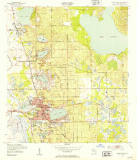
(44)- 1950 Map of Mulberry
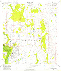
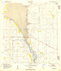
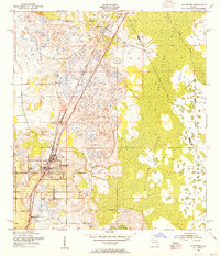
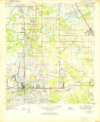 1950 Mulberry1950 Print · USGSThe phosphate mining district around Mulberry is captured here at mid-century, showing a landscape defined by industry and rail. Genealogists and historians can trace old settlements like Tancrede and locate rural landmarks such as Medulla Ch and Prairie Cem.
 - 1950 Map of Bartow
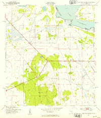
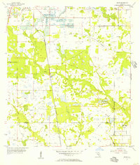
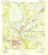 1950 Bartow1950 Print · USGSMid-century Bartow and the central Florida phosphate district are seen here during a period of industrial expansion. Genealogists and researchers can locate old schools like Union Academy, rural churches like Macedonia Ch, and the sprawling Strip Mine Area that reshaped the local terrain.
 - 1950 Map of Bradley Junction
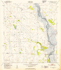
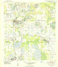 1950 Bradley Junction1950 Print · USGSMid-century Polk County is defined here by its massive phosphate industry and the tight-knit railroad towns that supported it. Trace the extensive rail network connecting Bradley Junction to mining hubs like Agricola and the company town of Brewster.
 - 1952 Map of Homeland, 1953 Print
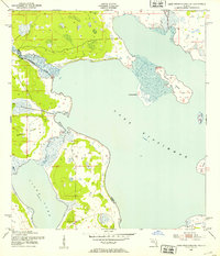
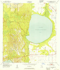
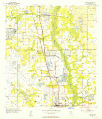 1952 Homeland1953 Print · USGSIn the early 1950s, the landscape around Fort Meade and Homeland was defined by the transition from river-bottom wetlands to large-scale phosphate mining. Researchers can trace family history through Evergreen Cem and Hancock Cem, or follow the industrial growth at the Noralyn Mine and Pembroke landing field.5 unique versions available
 - 1952 Map of Lake Wales, 1953 Print
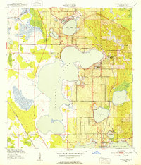
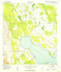
 1952 Lake Wales1953 Print · USGSThe Florida ridge country comes into focus in the early fifties, showcasing a landscape of citrus groves and interconnected lakes. Trace the intersecting tracks of the Atlantic Coast Line and landmarks like Bok Tower and Roosevelt Sch.9 unique versions available
 - 1952 Map of Lake Weohyakapka SE, 1953 Print
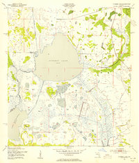
 1952 Lake Weohyakapka SE1953 Print · USGSCentral Florida's lake country in the early fifties shows a landscape of wetlands and early transport corridors at the Polk and Osceola county line. Researchers can trace the path of an Old Railroad Grade or explore the shoreline of Brahma Island and Lake Kissimmee.5 unique versions available
 - 1952 Map of Lake Weohyakapka NE, 1953 Print
 1952 Lake Weohyakapka NE1953 Print · USGSOsceola and Polk counties appear here in the early fifties, showing the expansive wetland systems of the Florida interior. Researchers can trace the original shoreline and named features like Sturm Island, Brahma Island, and the winding Kissimmee River.4 unique versions available
 - 1952 Map of Fort Kissimmee NW, 1953 Print
 1952 Fort Kissimmee NW1953 Print · USGSCentral Florida's interior in the early fifties is captured here as a landscape of military range lands and winding river wetlands. Researchers can trace the original path of the Kissimmee River and explore named landmarks like Hard Luck Hammock and Ice Cream Slough.3 unique versions available
 - 1952 Map of Lake Arbuckle NE, 1953 Print
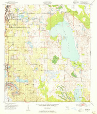
 1952 Lake Arbuckle NE1953 Print · USGSAcross the Polk and Highlands county line in the early fifties, this area was defined by the massive footprint of the Avon Park Air Force Base. Researchers can trace the Government Railroad and the engineering of the Rim Canal along Lake Arbuckle.4 unique versions available
 - 1952 Map of Babson Park, 1953 Print
 1952 Babson Park1953 Print · USGSPolk County at mid-century reveals a landscape of citrus groves and interconnected lakes just as local infrastructure was expanding. Trace the routes of the Seaboard Air Line and find landmarks like Bethel Ch or the settlement at Frostproof.3 unique versions available
 - 1952 Map of Hesperides, 1953 Print
 1952 Hesperides1953 Print · USGSPolk County at the start of the 1950s was a landscape defined by expansive lakes and the citrus-belt rail lines. Genealogists and historians can trace local landmarks like the St Anne Shrine and Beulah Ch or the rural stops at Alcoma and Hesperides.4 unique versions available
 - 1952 Map of Lake Arbuckle, 1953 Print
 1952 Lake Arbuckle1953 Print · USGSThe Florida interior during the early fifties reveals a landscape shaped by military expansion and natural hydrology. Genealogists and historians can trace the U S Government Railroad and the small settlement of Alpine near Lake Pythias.3 unique versions available
 - 1952 Map of Lake Weohyakapka, 1953 Print
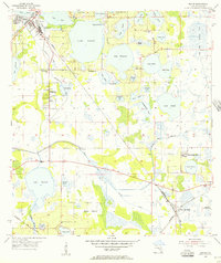
 1952 Lake Weohyakapka1953 Print · USGSPolk County, Florida, in the early fifties shows a landscape of expansive wetlands and early rail transit. You can trace the path of the Seaboard Air Line Railroad and explore the natural margins of Tiger Creek Hammock and Blue Jordan Swamp.4 unique versions available
 - 1953 Map of Frostproof, 1954 Print
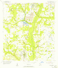
 1953 Frostproof1954 Print · USGSFrostproof and the surrounding Florida lake country are shown in the early fifties as the region's citrus and rail economy flourished. Researchers can trace the junction of the Seaboard Air Line and find rural landmarks like Maxcy Quarters and Corinth Ch.5 unique versions available
 - 1953 Map of Cypress Lake, 1954 Print
 1953 Cypress Lake1954 Print · USGSOsceola and Polk counties meet in this mid-century survey of the Florida wetlands before extensive modern development altered the region's hydrology. Genealogists and local historians can trace family-named landmarks like Ike Hammock, Johnson Island, and the early route of Canoe Creek Road.4 unique versions available
 - 1953 Map of Dundee, 1954 Print
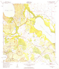
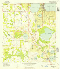
 1953 Dundee1954 Print · USGSHaines City and Dundee sit at the heart of this early 1950s survey of Polk County's lake-studded landscape. Researchers can trace the Atlantic Coast Line railway as it connects local hubs near Lake Hamilton, Lake Ruth, and the Boy Scout Camp on the shores of Lake Marion.6 unique versions available
 - 1953 Map of Lake Marian SW, 1954 Print
 1953 Lake Marian SW1954 Print · USGSOsceola and Polk Counties appear here in the early fifties, showing the wild wetlands at the head of the Kissimmee River. Genealogists and local historians can trace family-named landmarks like Godwin Hammock or follow the paths of Buttermilk Slough and Ice Cream Slough.3 unique versions available
 - 1953 Map of Lake Hatchineha, 1954 Print
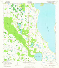
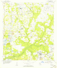
 1953 Lake Hatchineha1954 Print · USGSCentral Florida's wetlands and hammocks are captured in the early 1950s along the Osceola and Polk County line. Researchers can trace the natural shoreline of Lake Hatchineha and find local landmarks like Lyle Camp and Johnson Island.4 unique versions available
 - 1953 Map of Lake Tohopekaliga, 1954 Print
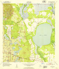
 1953 Lake Tohopekaliga1954 Print · USGSThe Florida interior near Lake Tohopekaliga was a landscape of expansive wetlands and scattered upland islands in the early fifties. Genealogists and historians can locate Pleasant Hill Cem and trace the original reaches of Reedy Creek Swamp.5 unique versions available
 - 1953 Map of Intercession City, 1955 Print
 1953 Intercession City1955 Print · USGSCovers Polk County, including Celebration, Intercession City, and other nearby areas6 unique versions available
 - 1953 Map of Davenport, 1955 Print
 1953 Davenport1955 Print · USGSDavenport and the surrounding Central Florida wetlands are captured here in the early fifties before the arrival of major theme parks. Genealogists and local historians can locate Little Zion Ch, trace the Atlantic Coast Line through Loughman, or explore the reaches of the Reedy Creek Swamp.5 unique versions available
 - 1955 Map of Eloise, 1956 Print
 1955 Eloise1956 Print · USGSCentral Florida's lake country is captured here during the mid-fifties, showing the intersection of rail commerce and growing citrus-belt settlements. You can trace the early layout of Cypress Gardens or locate rural landmarks like Rifle Range Ch and Mule Island.6 unique versions available
 - 1955 Map of Bowling Green, 1956 Print
 1955 Bowling Green1956 Print · USGSCentral Florida's phosphate district comes into focus during the mid-fifties as industrial mining expands between Fort Meade and Bowling Green. Researchers can trace family roots at Fort Meade Cem or locate rural landmarks like Mount Pisgah Ch and the Atlantic Coast Line rail corridor.4 unique versions available
 - 1955 Map of Nichols, 1956 Print
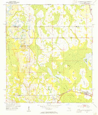
 1955 Nichols1956 Print · USGSThe industrial and agricultural heart of the Hillsborough-Polk border comes alive in the mid-fifties, dominated by phosphate mining and rail transport. Researchers can trace the heritage of rural communities through Coronet, the Glover Sch, and Springhead Cem.4 unique versions available
 - 1955 Map of Baird, 1956 Print
 1955 Baird1956 Print · USGSPhosphate mining and rural prairie life intersect in this mid-century Florida interior. Genealogists and historians can locate the community at Brewster, trace the Seaboard Air Line, and find local landmarks like Welcome Ch and Pierce Lookout Tower.4 unique versions available
Showing maps 1-25 of 44
Top cities of Polk County
- Lakeland historical maps
- Winter Haven historical maps
- Bartow historical maps
- Haines City historical maps
- Lake Wales historical maps
- Auburndale historical maps
See more
Frequently asked questions
- What are the different types of historical maps available for Polk County?
- What is the oldest map of Polk County?
- Where can I purchase historical maps of Polk County for my home or office?
- Where can I download high-res historical maps of Polk County?
- Are there historical topographic maps available for Polk County?
- Is there historical aerial imagery available for Polk County?
- Where are historical maps of Polk County sourced from?