1960s Maps of Polk County, Florida
Explore 5 historic maps of Polk County from the 1960s. These maps offer a rare glimpse into what life looked like during the 1960s — showing old roads, neighborhoods, homes, and landmarks that have changed or disappeared over time.
Whether you're researching your family's past, planning a metal detecting trip, or studying how Polk County's landscape evolved across the 1960s, these high-resolution maps are a powerful tool for exploring the history of this region.
- Focus on a specific era: All maps on this page are from the 1960s, giving you a focused view of this time period.
- See what’s changed: Compare century-old streets, trails, and buildings to today's modern landscape using overlays and satellite layers.
- Research with precision: Use these maps for genealogy, historical research, land use analysis, or educational projects.
- View, download, or print: Maps are fully viewable online in high resolution, and can be downloaded or printed for your own records.
Start exploring Polk County's history through authentic maps from the 1960s. This is your window into the past.
Polk County, FL maps
(5)- 1960 Map of Tampa
 1960 Tampa1960 Print · USGSThe Florida Gulf Coast was undergoing a major transformation at the start of the sixties, with new bridges linking burgeoning cities across the bays. Researchers can trace the mid-century footprints of St Petersburg and Tampa, or locate coastal landmarks like Mac Dill AFB and the Sunshine Skyway.2 unique versions available
 - 1960 Map of Branchborough, 1962 Print
 1960 Branchborough1962 Print · USGSThe swampy interior of Florida at the tri-county border shows a landscape of riverine hammocks and early forest industry in the 1960s. Genealogists and historians can trace the foundations of Branchborough and locate Withlacoochee Cemetery and Port Lonesome.4 unique versions available
 - 1960 Map of Rock Ridge, 1962 Print
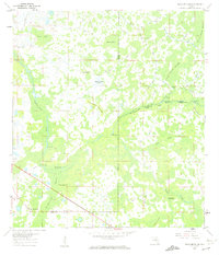
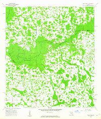 1960 Rock Ridge1962 Print · USGSThe Florida swamp country at the edge of Polk and Sumter Counties comes into focus during the early sixties. Genealogists and historians can trace the foundations of the Rock Ridge community, including Little Flock Ch and numerous segments of an Old Railroad Grade.4 unique versions available
 - 1962 Map of Orlando
 1962 Orlando1962 Print · USGSCentral Florida was transformed by aerospace and citrus at the start of the sixties. Genealogists and historians can trace old community footprints from Eau Gallie to Leesburg, alongside landmarks like McCoy AFB and the winding Econlockhatchee River.
 - 1964 Map of Plant City
 1964 Plant City1964 Print · USGSThe West Florida coast and its interior rail corridors come alive in this mid-sixties survey, spanning from the gulf marshes to the agricultural heartland. Researchers can trace the routes of the Atlantic Coast Line through settlements like Bushnell, Inverness, and Plant City.
End of results
Showing maps 1-5 of 5
Top cities of Polk County
- Lakeland historical maps
- Winter Haven historical maps
- Bartow historical maps
- Haines City historical maps
- Lake Wales historical maps
- Auburndale historical maps
See more
Frequently asked questions
- What are the different types of historical maps available for Polk County?
- What is the oldest map of Polk County?
- Where can I purchase historical maps of Polk County for my home or office?
- Where can I download high-res historical maps of Polk County?
- Are there historical topographic maps available for Polk County?
- Is there historical aerial imagery available for Polk County?
- Where are historical maps of Polk County sourced from?