1940s Maps of Eagle Lake, Florida
Explore 2 historic maps of Eagle Lake from the 1940s. These maps offer a rare glimpse into what life looked like during the 1940s — showing old roads, neighborhoods, homes, and landmarks that have changed or disappeared over time.
Whether you're researching your family's past, planning a metal detecting trip, or studying how Eagle Lake's landscape evolved across the 1940s, these high-resolution maps are a powerful tool for exploring the history of this region.
- Focus on a specific era: All maps on this page are from the 1940s, giving you a focused view of this time period.
- See what’s changed: Compare century-old streets, trails, and buildings to today's modern landscape using overlays and satellite layers.
- Research with precision: Use these maps for genealogy, historical research, land use analysis, or educational projects.
- View, download, or print: Maps are fully viewable online in high resolution, and can be downloaded or printed for your own records.
Start exploring Eagle Lake's history through authentic maps from the 1940s. This is your window into the past.
Eagle Lake, FL maps
(2)- 1944 Map of Auburndale
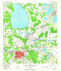
 1944 Auburndale1944 Print · USGSPolk County was a hub of citrus and industry during the mid-forties, characterized by its dense lake systems and rail junctions. You can trace family homesteads near Fussells Corner, locate the old Phosphate Mines, and see the early footprints of the Winter Haven Airport.2 unique versions available
 - 1949 Map of Bartow, 1964 Print
 1949 Bartow1964 Print · USGSMid-century Bartow and the surrounding phosphate country are shown here just as industrial mining began to reshape the landscape. Genealogists and historians can locate Union Academy, trace the old Atlantic Coast Line tracks, or find family plots in Oak Hill Cem.5 unique versions available
End of results
Showing maps 1-2 of 2
Top cities near Eagle Lake
- Lakeland historical maps
- Winter Haven historical maps
- Bartow historical maps
- Haines City historical maps
- Lake Wales historical maps
- Auburndale historical maps
See more
Frequently asked questions
- What are the different types of historical maps available for Eagle Lake?
- What is the oldest map of Eagle Lake?
- Where can I purchase historical maps of Eagle Lake for my home or office?
- Where can I download high-res historical maps of Eagle Lake?
- Are there historical topographic maps available for Eagle Lake?
- Is there historical aerial imagery available for Eagle Lake?
- Where are historical maps of Eagle Lake sourced from?