1990s Maps of Lakeland, Florida
Explore 3 historic maps of Lakeland from the 1990s. These maps offer a rare glimpse into what life looked like during the 1990s — showing old roads, neighborhoods, homes, and landmarks that have changed or disappeared over time.
Whether you're researching your family's past, planning a metal detecting trip, or studying how Lakeland's landscape evolved across the 1990s, these high-resolution maps are a powerful tool for exploring the history of this region.
- Focus on a specific era: All maps on this page are from the 1990s, giving you a focused view of this time period.
- See what’s changed: Compare century-old streets, trails, and buildings to today's modern landscape using overlays and satellite layers.
- Research with precision: Use these maps for genealogy, historical research, land use analysis, or educational projects.
- View, download, or print: Maps are fully viewable online in high resolution, and can be downloaded or printed for your own records.
Start exploring Lakeland's history through authentic maps from the 1990s. This is your window into the past.
Lakeland, FL maps
(3)- 1994 Map of Lakeland, 2000 Print
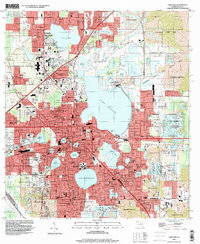 1994 Lakeland2000 Print · USGSLakeland and its surroundings are shown in the mid-nineties as the region successfully transitioned former industrial lands into extensive recreation areas. Genealogists and local historians can locate several landmarks like Roselawn Cem, Griffin Cem, and the campus of Florida Southern.
 - 1994 Map of Plant City East, 2000 Print
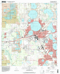
 1994 Plant City East2000 Print · USGSHillsborough and Polk counties meet here in the mid-1990s as agriculture and industry expand around Plant City. Researchers can trace local landmarks like Oaklawn Cem, the Former Mine, and the rail lines of CSX Transportation.
 - 1994 Map of Auburndale, 2000 Print
 1994 Auburndale2000 Print · USGSIn the mid-1990s, the Auburndale and Winter Haven area reveals a fascinating landscape of industrial reclamation and lakeside settlement. Researchers can locate local landmarks like Auburndale Memorial Park, the Winter Haven Motor Speedway, and the expansive Reclaimed Strip Mine areas of the Tenoroc State Fish Management Area.
End of results
Showing maps 1-3 of 3
Top cities near Lakeland
- Winter Haven historical maps
- Plant City historical maps
- Bartow historical maps
- Auburndale historical maps
- Lake Alfred historical maps
- Mulberry historical maps
See more
Top neighborhoods of Lakeland
Frequently asked questions
- What are the different types of historical maps available for Lakeland?
- What is the oldest map of Lakeland?
- Where can I purchase historical maps of Lakeland for my home or office?
- Where can I download high-res historical maps of Lakeland?
- Are there historical topographic maps available for Lakeland?
- Is there historical aerial imagery available for Lakeland?
- Where are historical maps of Lakeland sourced from?